ZuiderzeeRoute 2018

Introduction

“Well, its flat isn’t it?”, said everyone we spoke to about our next adventure. After last year’s tour to Spain and France, and the incredible amount of climbing we had to do over the Pyrenees mountains – I have told you that we don’t do climbing haven’t I? I did? Sorry; just thought I’d mention it – we decided to go for endurance in the saddle rather than climbing lots of mountains this year; something we are both better built for and where better than the European country which is the most famous for being flat. Holland!

This year we chose to cycle the ZuiderzeeRoute in the Netherlands. It is a circular route that (mostly) follows the coast of the IJsselmeer, which is a closed off bay bordering Flevoland and Freisland in Northern Holland. Closing off the bay from the sea resulted in a freshwater lake evolving as the water run-off from the land diluted the salt water over the years to extinction. The official route around the man-made lake is 400km (approximately 249 miles) but as the ferry from the UK would land us at the sea port of Ijmuiden twenty or so miles west of Amsterdam, we decided that it made perfect sense to start and end the tour at the ferry port. This spur was therefore incorporated into our tour. We would pick up the official route of the ZuiderzeeRoute where is traverses Amsterdam. This extra mileage would take our total journey distance to just over 300 miles, which would be a new record for a BoysGoneBiking tour. The ferries were booked. The hotels sorted. Restaurants organised. The challenge was set.

Day 0 :: Cheshire to Ijmuiden

After completing a couple of last minute jobs – haircuts and transfer of the official route maps onto our GPS system – we set off from our home county of Cheshire up to the North East of England to pick up our ferry from the Port of Tyne in South Shields. The day was cold and grey but we were optimistic that the weather would improve as we went across the North Sea and onto the continent. The trip up to South Shields was good with no traffic problems (surprisingly), and after a quick stop for a Maccy D’s and a terribly healthy Krispy Kreme doughnut for lunch to kick start the carbo loading, we arrived at the Port of Tyne. It was a small sea port which meant no hassle with crowds of cars, campervans or lorries. The secure car park was right at the side of the check in area and was quiet, so we parked up as close to the port entrance as we could and unloaded the bikes. Front wheels reattached and luggage – panniers, handle bar bags and under seat tool kit – on-board, we cycled down to the check in desks.

As the port is not big or sprawling you get to see the large ferry – the DFDS Princess Seaways – docked just the other side of passenger terminal. She was quite a sizeable looking ship compared to others that we’d sailed on whilst crossing the English Channel for previous tours.

The check in process was smooth and simple. “Ooh, you’re in the nice restaurant for dinner”, we were told by the lovely Geordie lass at the check in desk. Did she mean the normal restaurant was terrible?! We would never find out as we had booked the “nice restaurant” for dinner on the way out to Holland and on the return journey. Quite glad we did by all accounts.

We cycled through the Border Patrol and were directed straight onto our ship. We walked up the rear entry ramp and were told to strap our bikes to the fencing at the side of the car deck. Within minutes of walking onto the ship the doors were closing. It felt like we had only just made it in the nick of time, and I thought we were doing so well! Never mind, we’d made it safely on board, so we headed off upstairs to find our cabin amongst the rows of identical corridors and doors. The cabin was cosy enough (i.e. small) but perfectly fine for the two of us for the one night of the crossing.

View from the Princess Seaways leaving the UK. Gloomy skies over head.

At 5pm, with a loud bellow of the ship’s horn, we set off on our journey across the North Sea. The “nice” restaurant was the North Sea Bistro, and she was right; it was very nice. A fantastic meal of Lobster Bisque, followed by a steak with all the trimmings, and a crème brûlée, all washed down with a bottle of red wine and coffee to finish was a lovely start to our trip and a relaxing way to while away a couple of hours. We had a window table too, so were able to watch the coast line of the UK float slowly by – the route to Holland from the North East hugs the coast of England right down towards Kent before heading across the sea to the continent, so we were in sight of land for a lot of the evening. After dinner it was predictably up to the bar. There was entertainment provided in the form of a guy singing to his guitar in the Compass Bar or a group called “Sky Fall” in the main stage area. There was even a cinema – it must have been very small – and a casino, with croupiers manning a roulette wheel and a blackjack table, as well as numerous slot machines to suck your cash out of you. Plenty to keep you occupied on the almost 17 hour crossing. We decided to grab a table near the bar in the main entertainment area and see what “Sky Fall” could provide to keep us amused. They were mildly amusing, especially after a couple of pints of lager, and they helped to pass the time as we progressed slowly towards our destination. The house band reached the end of their set about 11.30pm, so we sensibly decided to head back to our cabin rather than order another beer. We had a long day ahead of us tomorrow, and trying to cycle 60 miles with a hangover would not be a good idea. We can be sensible when we need to be; well usually most of the time!

Day 1 :: Ijmuiden to Hoorn

Unlike the Brittany Ferries of previous tours, there was no gentle music to softly wake you from your slumber, just a crackly announcement over the in-cabin tannoy that breakfast was being served in the self-service restaurant. We opened our curtains covering the porthole window to reveal blue skies; the same thing happened two years ago when arriving in St. Malo in France to cycle Le Petit Tour de Manche. We left a cold, grey and wet UK to land on the continent with blue skies. We couldn’t believe our luck once more, as the forecast the week before the tour was promising grey skies with a dead-cert chance of rain.

After showering we headed upstairs to the Explorers Kitchen for a buffet breakfast. This was the usual affair of queues, crowds, and over cooked, dried out food. I think we definitely made the right choice with the Bistro Restaurant last night. We found some edible bits and bobs, mostly toast and eggs which are good food types for cycling at any rate, and ate what we could to load up ready for the days cycling. We promised ourselves something better for lunch.

After a trip back down to the cabin to change into the BGB cycling gear and repack our bags, we went back to the car deck to untie the bikes and load them up ready for the off. The process of unloading a ferry is a tedious one, and it seemed to take an inordinate amount of time to let the cyclists – of which there were a lot – push their bikes down the exit ramp. Eventually we were allowed to exit the ship through the forward doors and make our way out and onto dry land. There was a small queue of cyclists waiting to have their passports checked. After a few gruff questions from a burly border patrol officer about why we were here and where we were going (in the nicest possible way), we were through the port gates to where the BGB 2018 Tour would officially begin; the Dutch town of Ijmuiden.

The Princess Seaways port side in Ijmuiden. Beautiful blue skies ready for the off…

The first leg of the Tour was not part of the Zuiderzee Route. It was a spur that we had located using cycle paths all of the way from the ferry port at Ijmuiden to Amsterdam, from where we could pick up the official Zuiderzee Route and start the loop of the IJsselmeer in a clockwise direction. There were two possible directions to go from the port, and unfortunately we took the wrong one. Our GPS beeped as it does when you go off route, within a minute of starting out. So we got out Google Maps just to see exactly what was going on. We were on the wrong side of a diverging triangle. A quick left turn through the town brought us to the other side of the triangle and the GPS was happy that we were back on track. The route tracked alongside the main road towards Amsterdam, and it was clear that the Dutch were very clued up on how to keep cyclists safe. Everywhere we looked there were clearly marked cycle routes. Usually they were off the road, but even where they were on-road, they were clearly marked and the drivers took great care to keep away from us. At the traffic lights there were separate lights for cyclists that allowed us to have a safe passage across the main roads whilst cars and pedestrians waited for us! We were going to like it cycling here.

The route was generally industrial as we headed towards the capital, with large business storage units on both sides of the road. There were also a colossal number of wind turbines wherever you looked; these huge structures dominating the landscape in all directions like mighty statues. They made quite an eerie whoosh, whoosh, whoosh sound as they rotated gracefully around in the wind. It was obvious that they were taking full advantage of their mostly windy flat country to generate renewable energy.

Slowly, as the day progressed, we noticed more domestic looking buildings appearing. The aircraft overhead were ever present as they headed into Schipol Airport. We knew that we must be getting nearer to the city. Even though we were getting closer to Amsterdam, there was still a lot of greenery around, with the cycle paths keeping us alongside narrow rivers and small lakes. There was a lot of water in this part of the world, and the houses seemed to aggregate along the banks of the rivers to get the best outlook over the water.

The river side path passed alongside the first traditional Dutch windmill we’d seen – a huge wooden structure brightly painted in red – before it ended on a busy main road. Still we had safe separation on cycle paths which had their own mini traffic light system to control the flow. We safely crossed the busy main road and started to head into an increasingly built up area which was the start of the capital city of Amsterdam. We hadn’t managed to get any water this morning coming from the port so we thought we’d better seek out a supermarket now that we were in town. We found a coffee shop – La Casa de Michael, and no it was not that type of coffee shop, you understand – and stopped for a coffee and a bit of a rest. Whilst we sat pouring over the maps for the beginning of the main route we noticed a sign for Lidl at the end of the street; perfect timing. We finished our coffee and cycled the short distance to the supermarket to get some water on board.

A bridge in the centre of Amsterdam.

After filling up the water bottles and stocking up the panniers with water, we applied sun cream and finally retraced our steps back to the main road. The route we were following was headed further into the city along the Haarlemmerstraat, passing by designer shops and cafes that did look like those types! When we first looked at the route linking the ferry port to the start of the Zuiderzee, we thought it skirted around the centre of Amsterdam, but as we cycled on it was becoming increasingly clear that we would get to see some of the centre of the city too. It quickly became progressively busier as we hit the middle of Amsterdam. We saw a canal with the typical Dutch scene; tall narrow houses, river boat taxis, bicycles, and bridges. It was quintessential Amsterdam right before our eyes and it was fantastic.

The route took us along a busy high street before we came to a large bustling area with cars, bicycles and trams all buzzing around and in between each other; chaotic but all seemingly moving in perfect unison. We crossed the tram tracks and busy square, heading towards the Amsterdam Central railway station. Up ahead, we noticed the biggest multi-story bike park we’d ever seen – not that we’d ever really seen a multi-story bike park before. There were literally thousands of bicycles parked side by side up a long spiral. Apparently, only one in four Dutch people own a car and we could see why. Who needs a car when the country you live in is so bicycle friendly! We cycled through an underpass which brought us to the water front by the station’s main entrance. Here there were commuters by the hundred heading to the busy ferries to cross over to the north side of the river. You had to be careful cycling around here as it was too easy to get swept along with the crowds. We got off and pushed our way slowly through the thick crowds to get a better sight of the waterfront.

The busy waterfront outside “Amsterdam Centraal” Railway Station.

It was an impressive scene in front of us, with numerous boats and ferries criss-crossing over the river to the north bank. After a few obligatory photos, we took to the cycle path again which followed along the water front, taking us past several river cruise ships before crossing a large bridge over a branch of the main river. The cycle path carried on sandwiched between the shop units on our left and the main road and then railway track on our right, until it took a sharp dog-leg left and immediately right past a large Chinese restaurant – the “Happy Happy Joy Joy”; great name and we wondered if it sold more than just chow mein! It did look very inviting and despite promising ourselves a good lunch today it was still too early; we were not yet on the main route so we had to press on.

We tracked through an area that was more residential than retail with apartments and office blocks on both sides. There was a large indoor market on our left, busy with shoppers. The cycle path wound left and right along wide avenues with tree lined central grass verges, before we were taken away from the road and onto a riverside path. There were more riverside properties giving fantastic views over the water to their owners. The cycle path ended abruptly at a road which turned right. We stopped to enjoy the view back down the river from a bridge that crossed it – there were some unusual houses on floating pontoons at the side of the river – and to check the maps as we thought we should be seeing signs for the Zuiderzee route by now. The sat nav seemed to indicate it was still several miles away! Had we got lost as we crossed through Amsterdam? We didn’t think so. Closer inspection of the sat nav cross referenced with Google Maps showed that we were looking at the wrong end of the line! We were in fact just around the corner from where we should intersect the main route – school boy error; we often make a few of those on a tour. We carried on around the corner and saw the name of the street: the Zuiderzeeweg. It sounded promising, and suddenly, there on a lamp post just a little further down the aptly named Zuiderzeeweg was our first sighting of the Zuiderzee route – LF21a.

Our first sighting of the official ZuiderzeeRoute signage in the suburbs of Amsterdam. We were on track…

The main route is circular around the lake and is divided up into three main sectors; LF21a, LF22a, and LF23a. The LF stands for “Landelijke Fietsroutes” – rural or long distance routes in English – and the “a” denotes a clockwise direction, which we were following. There are also corresponding “b” signs to follow if you were to go aong the same route in an anti-clockwise direction. It is all beautifully simple and from what we had read before we came, the route is generally very well sign-posted. The official part of the 2018 Tour had begun.

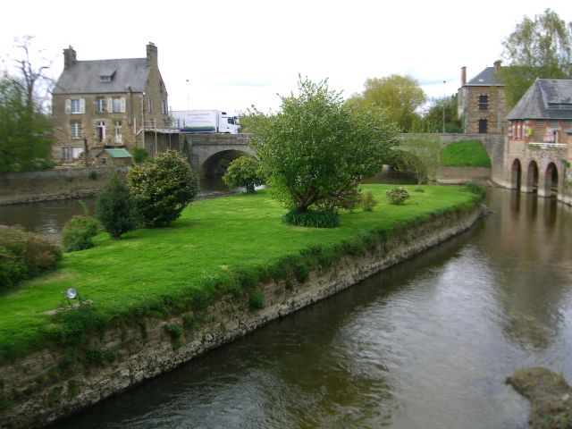
We headed over a long curved sweeping road bridge on a cycle path alongside the main road heading northwards out of Amsterdam, and through a residential area made up mainly of low-rise apartment blocks. There was a new wide bore pipe being laid across a busy main road, and it was currently suspended precariously high over the road on a make-shift scaffold bridge. We carefully crossed over the road and through the road works, passing beneath the long pipeline suspended above our heads, all the time still safely on our cycle path. The route turned off the main road as it headed toward Durgerdam and the coast. The level of the road was below sea level at this point and there was a long levee obscuring the view of the lake. The levee eventually lowered to reveal our first proper sighting of the IJsselmeer that we had come all this way to cycle around. It looked magnificent with the sun glinting off the surface as we cycled along at our steady pace. It was about lunch time as arrived into Durgerdam. The town itself was small and quiet, focused mostly along the harbour with its many boats moored to floating pontoons. We cycled past what looked like a café on the waterfront so we stopped and went over to it to see if we could get some lunch. There were a couple of blokes outside fixing the awning over the entrance way. We asked if the café was open for lunch. It was a private members club and was not open to the public, but he directed us to a café further on into town – all in Dutch. We don’t speak Dutch but it has some similarities with German, so I could grasp the odd “links” and “recht” so we thanked them and cycled off to see if we could find the café they were trying to direct us towards.

We followed the route which seemed to coincide with the sparse instructions we had for the location of a café, but we did not come across it. Lost in translation I’m sure. We left Durgerdam and the main road to head inland. There were numerous small hamlets as we passed along the edges of the fields but nowhere that we could see to get some lunch. It was incredible, though, to see cycle paths alongside even these small isolated country lanes. The next village along was Ransdorp and it seemed larger than the previous village we had passed through. Our hopes for lunch were raised. We spotted a pub on the right as we cycled along the main street through the village – Hotel-Café De Zwaan. Even with my lack of Dutch I understood it was “The Swan”. Perhaps the large sign hanging on the outside wall of the pub of a swan swimming gracefully on a lake might have had something to do with it. It was open so we locked up our bikes against the fence opposite the pub and went inside. It was a small British looking bar, with a large billiards table dominating the room. There were a few locals enjoying a lunchtime beer and some chatter, and a weathered looking bar maid keeping their drinks topped up. It smelt of stale beer and old cigarette smoke. Not my idea of a pleasant lunch time atmosphere but we had limited choice and we were hungry. We ordered a couple of Cokes and checked out the menu. It was a simple affair but there were options; unlike the Zebra Café we ate lunch in whilst cycling Le Petit Tour de Manche in 2016 – cheese burger and chips was the only option back then, although it was very tasty! It was a cheese and ham toasty, eggs or meatball. We went for the eggs but we were not able to have that dish as “Mother was making her meatballs”. We were a bit puzzled why this meant we couldn’t have eggs, but settled on the meatball. The meatball arrived – singular as displayed on the menu: one large meatball! – sat upon two slices of dry white bread with some mayonnaise on the side. Bit odd we thought. We assumed it was a local dish so… when in Rome as they say! We ate the meatball and it was actually very tasty to be fair, it was just the unusual presentation and accompaniments that had us a bit stumped. We had a second Coke to wash it all down and restock our fluid levels and settled our bill, which was very reasonable. Overall it was a simple lunch but nice enough with plenty of protein to keep us going for the afternoon’s cycling up to Hoorn. We just wished the place smelt a little less like a 1970s dirty old man’s pub!

Through the village of Ransdorp, the road turned sharp left and then snaked its way through a vast expanse of fields, all criss-crossed with narrow drainage ditches. Holland is very vulnerable to flooding, but it is not until you see the complex infrastructure built everywhere to keep the land safe do you understand the scale of it all. We turned off the main road onto a smaller country lane, and the cycle path ended for the first time. We were on a shared road, but there was no traffic to worry us. This gentle cycle along field boundaries continued for some time. The sun was shining and the weather warm, so we ate up the miles enjoying the views as they appeared in front of us. We arrived at a small village called Zuiderwoude and passed by the central church which was in the typical Dutch style. Most of the churches we had seen so far were tall and narrow like the houses, with a tower and then a steeple on the top. This one was set back in its own grounds – a grave yard – and looked mighty impressive against the smaller surrounding houses. Clearly the focus of the village.

The small road continued beyond Zuiderwoude for another mile or two before meeting back with the main road at the side of the lake. The cycle lane was back and right up on top of the levee so we got a good view of the lake whilst the traffic buzzed away down below on the main road to our left. From our elevated position we could see a much larger town coming into view. A quick look at the map saw this town was Monnickendam and we would pass right through it and by its large harbour. This was a town I wanted to see as it is famous for its large masted ships crewed by groups of youngsters who want to learn the older more traditional sailing techniques. I was hoping we might see some of these old ships up close. The route went through what was clearly an older part of the town which took alongside the quay, and there as we’d hoped were several of the promised old ships with impressive rigging and huge sails which I’d read about in the guide book. They looked splendid and I’m sure we could have had great fun sailing around the lake aboard one. We took a few photos before pressing on over a traditional Dutch cantilevered lifting bridge and headed left along the quayside past bustling bars and restaurants through this busy little town.

Beautiful tall ships in Monnickendam.

Monnickendam was actually a sizeable town and it took a while to cycle across it. There were lots of interesting looking shops and more than a few cycle shops offering new sales, second hand bikes and repairs, which is perhaps not too surprising in such a cycle happy country. The road out of town went alongside a very busy main road before turning us right diverting us away from it. We stopped at a red light and noticed a shop opposite the junction selling cheese and clogs. So far today, on day one of the trip, we had seen windmills, dykes, and tulips, and now cheese and clogs. Was there anything left to discover in Holland now we could tick the obvious ones off the list? The sign for the clog shop was an enormous clog strapped to the top of a red double decker bus; and why not? It certainly had impact and is something that we will always remember.

Clogs and buses. Just a bit odd…

The trail was now back on the road but it was quiet. It was following the shore of the lake closely as we mainly passed by fields with the odd house or farm appearing into view as we went. We passed an old windmill on our right as we approached another town – Volendam. The trail left the road and climbed up a short way (quite a long way for Holland) and onto a brick paved road. The road was lined with houses and then shops as we moved towards the centre of town. The road met the shore line at the harbour where there were a lot of shops and people milling around. It was clearly a very touristy town and was so busy we had to get off and walk with our bikes for fear of bumping into someone! The shops were mostly aimed at the transient tourist trade, offering cheese, poffertjes (a Dutch speciality a bit like a mini pancake) and clogs, and they were doing a roaring trade. We stopped to admire a galleon type ship docked in the harbour before slowly picking our way between the crowds enjoying the sunshine and shopping for cheese and tat.

Another fabulous ship.

We passed along the busy high street through the middle of town, and eventually the volume of people thinned out to a point where it was safe to mount our bikes and continue our way in the saddle. The trail took to the levee again tracking the lake side. The “sat nav” beeped to us that we were off track so we quickly pulled up and checked where we were. We had passed a ninety degree left turn about one hundred yards back. We retraced our steps and located the missed signpost. We were too busy admiring the view over the lake to see the sign post at the turn. We noted to ourselves to keep a sharper eye out in future. We took the correct left turn which took us into the town of Breewijd. The trail was largely residential and not very interesting and we were wondering why it took us away from a glorious view over the lake to this. We followed the route for a few miles and it brought us to a new town – Edam. It now became clear why the route had diverted us away from the lake to here. Edam is probably the most famous of Dutch cheeses, and according to Wikipedia was the world’s most popular cheese between the 14th and 18th centuries because it travelled well without spoiling in the holds of large slow merchant ships. This is where it all started. We passed a huge bike park at the side of the train station and crossed over a bridge to enter the old town. The streets were very narrow and atmospheric with tall houses hunched shoulder to shoulder along both sides. The road widened out with the river flowing down the centre and the occasional bridge over the river to afford access to the other side of the street. It was very quaint to see and had a lovely relaxing feel to it. We passed by the official Edam Museum. We were not really sure quite how interesting a museum devoted to one or even several types of cheese would be and we didn’t really have time to explore it either, so we talked ourselves out of paying it a visit. It did look like an interesting little town though and if we were ever back this way we made a promise to spend more time exploring, and even visit the cheese museum.

The trail was heading back to the coast, turning us north again after our diversion through Edam. We cycled along for several relaxing miles, passing through the coastal villages of Warder, Etersheim, and Schardam. The route was mostly sandwiched between the lakeside on our right and the field boundaries on our left, and with the sun shining onto our faces it was making for a very pleasant afternoon; cycle touring at its best. It was after 6.00pm when we arrived into Scharwoude as we passed the 50 mile mark, and we knew that we couldn’t be too far away from our day one destination of Hoorn. We could see a large town across the bay to our right and according to the map this was Hoorn coming into view. The route was back onto the road with salmon pink cycle lanes at each side as we headed through Scharwoude towards Hoorn. After a further three miles we arrived into Hoorn passing by the quirky looking church and on to the pleasant harbour. I noticed tonight’s eatery, Restaurant Lucas Riva, to our left and I had memorised how to get to the hotel from here by looking at Google Maps last week. I lead us knowingly along the harbour and then over the bridge to find our hotel just on the left – the Hotel de Magneet. The hotel owner was there at the door to greet us as we pulled up. He explained how to get out bikes around to the secure garden at the back and gave us the key to our room. We walked our bikes around the back of the hotel and through the secure gate to the garden. We unloaded them of all their bags and locked them to the garden bike rack for a well-deserved rest. As we fastened the bike locks into place it started to rain. The timing could not have been any better.

The room was upstairs in one of the garden annex buildings. The stairs were steep with all our luggage and tired legs but we managed to get up there safely. The modern room was a good size with four comfortable beds. After unpacking, showering and changing into our evening garb, we headed out for a treat: a six course fine dining tasting menu with a wine flight at the Michelin starred Restaurant Lucas Riva. We had an incredible evening – despite me launching a glass of champagne over Mike courtesy of a wobbly table – enjoying all of the tasty food and accompanying fine wines. The service as well as the food and drink were excellent, and the main man himself even made the time to come to our table and have a chat about the food and what we were up to on our visit to Holland. We staggered back to the hotel with full stomachs and a little hazy from the endless wines, and slept soundly until morning.

Day 2 :: Hoorn to Makkum

We woke up early with surprisingly clear heads; it must have been to do with the quality of the wine we drank last night rather than the usual cheap plonk we partake in! We opened the blinds to clear blue skies, although the ground outside did look wet. It must have continued to rain in the night after we got back to the hotel. We showered and dressed back into our cycling gear before heading down to the main hotel restaurant for breakfast. It was a buffet style breakfast but with enough tasty croissants and muesli, plus eggs and toast to fill you up. After more orange juice and a couple of cups of tea we dried off the bike saddles and loaded them up with the panniers and bar bags, applying a good dose of GT85 to get rid of the water from the gears and lubricate them, and we were ready for the day ahead. Our itinery for today was to be just short of 65 miles to a town called Makkum on the eastern side of the IJsselmeer. Today would take us across the Afsluitdijk, the 20 mile long causeway built between 1927 and 1932 that connects the west side of the lake to the east side, and keeps the lake as a lake separate from the Wadden Sea. We were looking forward to crossing this incredible feat of engineering this afternoon.

We settled our hotel bill and chatted to the owner and another guest for a few minutes. Our fellow guest was an English chap who had come to Holland to lay flowers on his father’s grave. His father was shot down and killed not too far from Hoorn in a Lancaster Bomber during WWII. It was the Dutch Remembrance Day on Friday 4th May so he had come to celebrate the lives and bravery of the allied soldiers alongside the Dutch. We wished him well and said our thank yous and goodbyes before heading back out onto the trail. The route ran right past the hotel door which was a big factor when choosing the hotel, plus it was highly rated on TripAdvisor. So returning to the route was simple. We had learned our lesson from the first BGB Tour in 2013 – the Trans Pennine Trail – where some of our accommodation choices were ridiculously off route to the point where it took us an hour on one day to find our way back from the hotel to the main route; never again. From there on we vowed to find accommodation on or at least very close to the main route, something that had worked excellently for us ever since then, and this tour was no exception.

The route continued on the quiet cobbled streets through Hoorn and quickly separated away and onto a cycle path. The path took a right-angled turn to follow the lake shore line to our right. There were a lot of industrial looking buildings on our left as we tracked the coast. After a couple of miles the trail took another sharp turn to head inland towards the town of Wijdenes. We passed a lovely windmill at the side of the lake which had been converted into a house. There was a field of deep red tulips next to it. We stopped for photos of the lovely scene and commented how nice it would be to live in such a setting with incredible views of the lake from your bedroom window.

The idyllic Dutch scene.

Wijdenes was made up of residential houses with no shops that we could see. Local corner shops seemed few and far between in Holland, and it got us thinking just exactly where could the local’s pop out to in order to buy a pint of milk and a loaf of bread?! – And then we passed a Spar shop which must have been doing a roaring trade as the only place in town to buy anything to eat. The town was very neat and tidy and all the houses and gardens we passed looked beautifully kept. They were obviously very house proud. The route left the main road through the town and took us on a quiet country lane lined on both sides with tall trees. A small stream ran along the road side and the occasional house with a large garden was dotted beyond that on our route. Riding along the empty lane was fantastic in the sunshine, only interrupted by the dappled shade of the tree canopy. This road lead us out of Wijdenes but the trees, albeit in a younger form continued to line the way to another small town; Oosterleek.

Oosterleek was much smaller than the previous town but still beautiful. It felt like we were cycling through a model village with the road narrower and the houses in much smaller proportions than its bigger neighbour. The coast was back in our sights once more as we left the quaint town behind, turning left to track it northwards again. We were back on the lake side cycle path and made good time along the smooth tarmac. We stayed on this path until mid-morning when our thoughts turned to a coffee stop. We passed by a newly built caravan park as we headed further inland towards a town. Our eyes were peeled for somewhere to stop for a break. The cycle path took us through an underpass beneath the main road which led into town, and brought us directly into a small marina filled with moored boats – de Kolk. We spotted a café on the other side of the marina, so we tried to head over to investigate. The cycle path took us past a row of small cottages and on towards a steep metal bridge, but the only way forward that we could see would involve climbing up a steep set of steps to go over the bridge which is not something that would be fun with two fully loaded touring bikes. We back tracked past the cottages to check where we must have taken a wrong turn. The sign posts pointed back to the way we just came. It must be the right way, we thought. We were a bit confused by this, and whilst scratching our heads over our predicament we spotted a cyclist coming the other way. We decided to watch and see what he did. He cycled towards the steep steps that would take him over the bridge, and then cycled right past them and through a building which stood behind the bridge, coming out the other side to head in our direction. There was a tunnel through the building by the bridge! Feeling rather stupid that we didn’t spot this, we sheepishly cycled on back past the cottages and through the tunnel to reach the other side of the marina. After all that, the café was closed but we spotted a second one further along the marina which was open. We stopped and sat outside De Woeste Hoogte at a table in the sunshine, ordered a couple of cappuccinos and had a laugh about our inability to see a large hole under a building. Well, at least we now knew what to look out for in future.

We got our morning coffee break … eventually!

Coffees drank and biscuits finished, we saddled up again and retraced our steps back along the side of the marina to where the trail headed off and further into the town. The towns beyond the marina were Broekerhaven and Bovenkaspel. They were quite busy little towns with houses lining the route in the usual style, with the rooflines coming low down the side of the walls, and no shops. The road went literally straight through the town, and then took a ninety degree right turn next to a large square tower after passing over the railway via a road crossing. The residential houses continued as the road headed back towards the coast. There was an interesting looking gatehouse along this part of the route that bisected the road. The gate house or Koepoort was the original west gate into the harbour town of Enkhuizen. Clearly the road used to go through it, but the road was now wider and needed more breathing space so it went around it instead. We were glad to see that they didn’t just pull it down in the name of modernisation.

Beautiful west gate house at Enkhuizen.

We entered Enkhuizen with its delightful harbour area where we spotted more old fashioned ships moored up to the dock. Just as we passed the last ship and approached what looked to us like a fortified gate house, it started to play beautiful bell music from its clock tower. We stopped to listen. How nice it would be if British clock towers played such interesting tunes to strike the hour. The gate house was the Drommedaris. Built in the 16th century, it was the south gate house into Enkhuizen, which at the time was a fortified town. The unusual building was used as the entrance to the old harbour and a prison. The clock tower that entertained us so beautifully contained a carillon constructed with 44 bells. The building was heavily damaged by the RAF in bombing raids during World War II, and some of the damage can still be seen. Today the building is used as the town’s cultural centre, housing a café and as a venue to host events in the town.

After a little backing to and fro through the narrow streets, the cycle path reached the coast again and then headed north past a camping ground and then alongside a curious theme park. It was named Sprookjeswonderland and seemed quite spooky from the outside. Lots of little wooden houses, like evil goblin houses, were scattered around the dark woods. There were plenty of young children running around having fun so we supposed it could not have been too scary in there. The path wound its way around the theme park’s car park and then off back along the lake side.

Some lovely smooth miles followed as we quickly passed a few small coastal towns. It was getting towards lunch time and we could not see anywhere to eat in any of these small towns. Everything was residential or closed. As we were succumbing to hunger and despair, we noticed a large old building stepped back from the road with a sign outside – Stoommachinemuseum. Judging by the machines on display outside and our deduction from the word “Stoom”, it was a steam museum. There was a sandwich board on the pavement outside that promised chips and toasted sandwiches. It sounded like a good place to stop, and as we had no other immediate options we pulled into the museum grounds and found a bike park. We secured the bikes and headed to the little café.

Lunch time at the Stoommachinemuseum.

The café frontage was a small hatch in the visitors centre and when we asked for a toasted sandwich and chips, we were offered crisps to accompany the sandwich. Of course, in Holland chips are crisps, not chips as we know them and were looking forward too. So we settled down to a cheese and ham toasty with a packet of crisps and a coke. Not quite the delicious food we were planning for the trip, but we were so hungry we didn’t care too much. I finished with a stroopwafle and sent a photo of the delicious wafer biscuit treat to Katy (my wife), who use to live in Holland and wanted me to get her some. I told her that I had bought the last packet from the café – which I had – but I would try to find her some to take home later on during the trip. I never did find any to take home for her.

Lunch finished, we were too short of time to look around the museum itself. It looked very interesting from the outside but we had a long way to go before we would reach Makkum for the night. We got back underway by re-joining the cycle path outside the Stoommachinemuseum.

Back on the trail we headed north and very quickly arrived into a sizeable town called Medemblik. The route took us right through the centre of town which was lined with lots of cafés and bars. It looked like we had peaked too soon in our search for lunch. We passed through its harbour area with lots of street side cafes, and also saw a lovely steam train waiting at a station by the lake side. It was named “Bello – 7742” and it was built in 1905. One hundred and thirteen years old and still going strong!

We love a good old steam train.

The route north of Medemblik was fairly quiet with only the odd house dotted here and there between large fields. In the distance, over the lake, we could see our lake crossing coming into view. It looked an impressive sight from this distance and only became more impressive as we approached ever nearer. The cycle path took us into an industrial town called Den Oever and swept us around to the start of the Afsluitdijk crossing. Originally the Zuiderzee was an inlet of the Waddenzee, an intertidal zone in the southeastern part of the North Sea. It lies between the coast of north-western continental Europe and the range of low-lying Frisian Islands, forming a shallow body of water with tidal flats and wetlands. It has been designated as a UNESCO World Heritage Site.

The area around the former Zuiderzee was vulnerable to flooding. In 1916, a combination of a storm at sea and an enormous surge of water from the IJssel caused flooding in large parts of the area around the Zuiderzee. Dikes burst, people were killed and the damage was enormous. There had been talk of plans to tame the Zuiderzee for some time, and the engineer Cornelis Lely was now asked to produce a plan for the construction of the Afsluitdijk. Work began in 1927, and the last section was completed in 1932. The original plan was to drain the land behind the dam and reclaim it for farm land but this was met with fierce opposition because of the threat to the livelihoods and economies of the local town and fishermen living along the banks of the Zuiderzee.

The Afsluitdijk sections off the Zuidersee from the Waddenzee to form a lake – the Ijsselmeer – and over the last 80 years the water in the lake has become fresh water rather than salt water as a result run off from the surrounding banks and gradual dilution of the sea water.

Just before we set out along the length of the dam, we passed the first landmark of the tour – 100 miles!

Our first major mile stone – done!

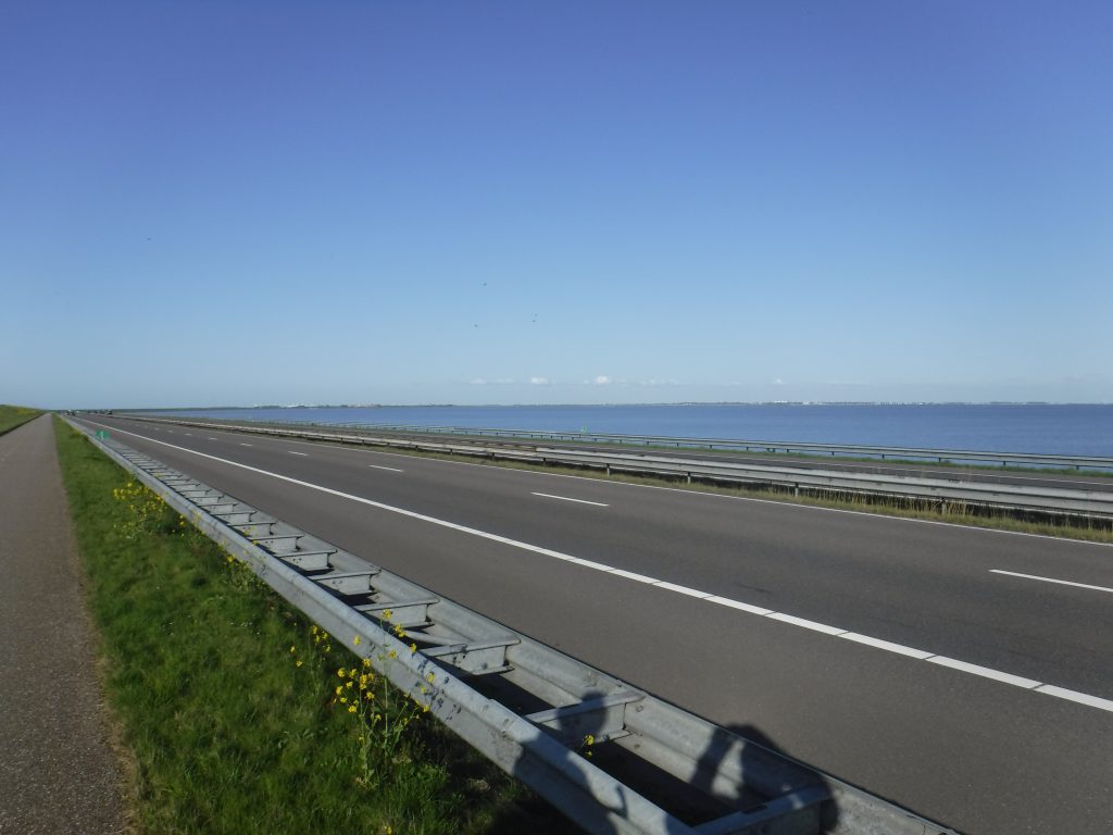
We headed out onto the dam’s cycle path which disappeared into the distance alongside the road, and we were met by huge clouds of small flies! They were sat in a long column right along the centre line of the cycle path and stretched as far as the eye could see. We had no choice but to suffer the flies as there was no alternative route to cross the dam. Needless to say we cycled with our mouths firmly closed and with our heads cocked to one side as much as you can when cycling a bike. The combination of sun cream on our hairy legs and swarms of flies was not a good mix, and we were soon caked in a thick layer of flies. We had been looking forward to crossing the Afsluitdijk, but this was totally gross and was spoiling our experience. Around about the half way mark there was a refuge and café area. We stopped and scraped off the flies from our legs. We bought an ice cream from the café to lift our spirits before carrying on, and on, and on. The dike is about 20 miles in length and apart from a slight deviation near the other side, was dead straight. The presence of the flies continued all the way to the other side. We were quite exhausted when we hit the other side of the lake because we had been breathing as little as possible to prevent taking in any flies. We stopped for a rest and to remove the remnants of the little buggers from all the nooks and crannies. The chains and cogs on our bikes were also covered in flies; utterly disgusting.

The Afsluitdijk. It looks so innocent, but what you can’t see are the flies. It was properly grim cycling!

After a rest, a clean-up and glucose sweets to keep us going, we set off again. The road we were on was heading to Zurich, but not that Zurich. We turned south for the very first time as the cycle route rounded the crest of the lake and started down the east bank of the IJsseleer. We were back on a country lane with a few cars and motor bikes for company, but nothing stressful. We were looking forward to that first beer of the day after our fly-filled ordeal passing over the dike. The road passed between a small island to our right and the mainland to our left, and eventually the town border sign for “Makkum” came into sight.

The route weaved its way through a residential area before arriving into the town itself. The hotel we were staying at was the “Hotel De Waag” and again was literally right on the route. We located it very easily in a pedestrianised area of the town. It was busy little town with a few bars full of people enjoying a beer or three; something we would be partaking in very shortly. The owner came out to meet us in front of his hotel – something that must be traditional in Holland. He advised us to go around the back of the hotel where there was a garage waiting for us to safely and securely store our bikes overnight. We unloaded everything first and put the bags inside the foyer of the hotel before walking the bikes around to the garage to lock them away for the night.

After checking in with reception we headed up the very steep stairs to unpack and have a quick shower before dinner. The room was not enormous but was comfortable enough with a hot powerful shower. What more do you need? The Hotel De Waag also rather coincidentally had one of the best TripAdvisor rated restaurants in Makkum, so it was an easy choice for us to eat in tonight. The owner showed us to our table and got us a couple of local beers. He explained the menu options to us in detail as our Dutch was pretty much non-existent, and we settled on a mixed grill and a delicious steak between us, finished with crème brûlée plus another beer or two. We decided against going out to explore the town as after two days in the saddle our legs and backsides were grumbling a bit and we were shattered. We headed up to our room and fell asleep pretty much instantly.

Day 3 :: Makkum to Blokzijl

The next day dawned bright and clear with beautiful blue skies. Our luck with the weather was continuing. After a further shower and dressing into the team colours, we headed down to breakfast. The breakfast room was separate from the main restaurant, tucked away at the back of the hotel and it displayed an impressive array of cereal, pastries, eggs, cheeses and meat, as well as toast and jam. The coffee was freshly brewed and strong. All excellent quality and we ate our fill to get as much energy on board for the day ahead.

After breakfast we settled the room account and then headed out of the back door of the hotel to the garage where we had locked the bikes the night before. We loaded the bikes and gave them their daily dose of GT-85 to keep them happy before heading back round to the front of the hotel in order to relocate the cycle route. Today we were heading to Blokzijl, a journey of 58 miles. The route went right through to the other side of town, crossed over a river inlet via a road bridge and then tracked the bank of a river on the opposite side of which was a huge building with Feadship XL on the side. It is the home of the Feadship Royal Dutch shipyard where they construct custom luxury super yachts; no two are the same! A bit beyond our pockets, so we didn’t stop to take a look. We soon left the town limits and the route crossed a roundabout before taking us back onto a quiet road right by the side of a narrow canal. The area around us was simply great expanses of green with very little else to see. The lake was hidden from view by the levee to our right which was home to many sheep slowly eating their way through the lush green grass. I’m sure it would be very exciting if you were a hungry cow or sheep, but for the cycle tourist it was a little uninspiring. Still, we had the blue skies over head and the fresh air to enjoy.

The road carried on through this bland country side for several miles until we arrived into the small town of Gaast, where the route took a sharp left turn down a narrow path and into the heart of the town. It felt as if we were cycling through people’s private property as the path wound literally right past people doors and windows. It was certainly much more interesting to cycle through the town and peep through peoples front windows than stick by the side of the endless levee. We left the town behind and cycled between more fields before re-joining the road again in the town of Ferwoude. The road headed back out towards the the levee, and there were fields on both sides. We assumed it was here to directly protect these small towns against severe flooding from the lake. We briefly touched the outskirts of Workum, leaving the town as quickly as we had arrived. From what little we saw of it, it looked like a very nice little place. Back to the fields again; this side of the lake seemed to be much less densely populated than the western side. Mostly fields with small villages dotted here and there. The route headed ever slowly southwards and back to the coast, deliciously looping around the town of Hindeloopen, where we crossed a metal bridge and spied a fantastic looking quirky wooden bridge further down the canal.

An interesting old wooden bridge in the distance.

We passed a few coast-side camp sites on the way towards Molkwerum, and it was around mid-morning and with our thoughts turning to coffee when we pulled into the picturesque town of Stavoren.

We stopped at the harbour side as we spotted De Hotel Vrouwe van Storen, which had a lovely alfresco seating area outside in the sunshine. It looked too good to pass by, so we locked up the bikes and took a table for coffee and cake. It was a lovely place to sit with the sun beating down and watch the world go by for a bit. We could have stayed there all morning and enjoyed more cake but we still had a long way to go before we could stop for the day.

After taking a longer rest than we should have allowed, we were back in the saddle. We double backed on ourselves for a few yards to pick up the route again on the other side of the café. The road was surfaced with grey bricks set in a herringbone pattern rather than tarmac and it was a good surface to cycle on. It was also devoid of traffic. Crossing a couple of bridges over an inlet took us back to the coast road and out of Stavoren. The trail was now sandwiched between the ever present levee and a stream, all running parallel for some quite distance. The only feature to note on this section of the tour were the occasional cattle grid every few hundred yards giving a tender bottom-nudging rumble to the back side as we passed over them. We quickly learned to stand up as we traversed them. This vista did not change much for quite some miles apart from the lake putting in an appearance as the levee lowered. This area forms part of the National Park Weerribben-Wieden which is why it is so sparsely populated, which is no bad thing and joking apart, was pretty breath-taking to cycle through.

We spotted what looked like a monument on our left which was described on the adjacent sign posts as the monument to the Battle of Warns. Having never heard of this battle, we Googled it; The Battle of Warns was a battle from the Frisian-Hollandic War between Count William IV of Holland and the Frisians which took place on 26 September 1345. The Frisians won the battle and repelled the Dutchmen from the eastern coast of the Zuiderzee. It looked like a lump of well-worn rock but it was very old so is not surprising and it was interesting to come across amidst the more repetitive surrounding landscape.

Eventually, we saw what looked like a town appearing on the horizon. We passed through this town of Laaksum which was really just a small hamlet and we were soon out the other side and back onto the same road. This took us further inland now and through the village of Mirns. This village was surrounded by forested areas which was nice to see after the flat scenery of the previous miles. It was back to the coast as Mirns slowly disappeared into our rear-view mirrors. Sorry if this sounds a bit repetitive, but it rather was!

It was approaching lunch time and we had just coincidentally arrived into the town of Oudemirdum. The town was certainly bigger than the small villages and hamlets that we had been cycling through during the morning, so we hoped there might be a little café somewhere to get something to eat. We stopped on the route and there were certainly more houses about but no obvious places to stop for some lunch. We almost cut our losses and continued on toward the next town of Lemmer which looked much bigger on the map, but we had a hunch to cycle in the opposite direction off the route further inland. Within a minute we came upon what can only be described as the main high street through the town which had several cafes and restaurants to choose from; a perfect find.

We had a look up and down the street at all of the eateries on offer and settled on a little place call the “Brasserie de Brink”, mainly because it was busy, which is always a good sign for a restaurant, but it also had a free table in the sun. We locked up the bikes in a passage way to the side of the café and took our table. We quickly ordered some food and treated ourselves to a beer as this town pretty much marked the halfway point of our adventure. Cheers!

After we finished our lunch and beer, we stole a few more minutes rest in the warm sunshine before settling our bill and saddling back up, retracing our steps along the high street and back to the point where the road met the trail. Slowly the trail took us back towards the coast passing several farms along the way. The edge of the lake came back into view and you could clearly make out the more built up west coast where we had been just a few days ago. Further down the road they were doing some reinforcement work to the Levee but the cycle path bypassed this without any bother, apart from a few large stones to avoid on the cycle path. We crossed over a bridge with a great view of a wind turbine farm in the lake some miles in the distance.

The town of Lemmer slowly opened up before us. This was a big place, at least compared to other towns we had visited so far. The building works continued into town and the cycle path went right across a roundabout through the centre. The cycle path was a bit strewn with debris from the works but with care we navigated through it successfully. It was set in the middle of a dual carriageway with busy roads either side. We were certainly glad that we were not on these roads! We continued into town and past a huge harbour to our left full of big and small pleasure boats, and you could hear the constant “tink tink tink” of the boats rigging ropes banging against the main mast in the gentle breeze. A couple of minutes later, and quite unexpectedly, we came across a beach. It was quite a big beach and was clearly man-made at the edge of the lake but it looked very inviting and a lovely thing for the residents of Lemmer to have on their door step.

The man-made beach at Lemmer.

We crossed yet another bridge over yet another inlet and then headed back to the coast as the cycle path took us out of town and on our way to Blokzijl. There was a long row of wind turbines to our left as we continued along the coastal path, stood tall and neat like a row of soldiers keeping guard over the coastline. The scale of these things is immense when you get up close, and the noise they make is extraordinary. There were more wind turbines in the lake to our right. These were the same wind turbines we had spotted from the trail a couple of hours earlier ahead in the distance. We by-passed the town of Urk and arrived at a bridge crossing over a larger inlet of the lake. This was the point where the route split into two different branches; one following the coast and one heading inland around the other side of a natural island in the lake. Our route would take us along this inland spur. This would mean that we would not see the lake in all its glory again until we arrived at its southern edge nearer to Amsterdam as we close the loop.

We carried on along our inland spur which took us out into the open country again. This was similar to the trail we had followed in the morning but without the levee, so we did at least have views to either side to enjoy. There were some very long and very straight parts to the trail in this area and we were very much inland at this point, but it all made for a very pleasant afternoons cycling if not for sightseeing. The straight sections changed to winding roads after a few miles which made a welcome change and kept us alert. These bends in the road circumnavigated the numerous farms on this side of the lake. They mostly seemed to be cattle farms, sheep farms and pig farms. There was a river alongside us to our left which demarcated the border between Friesland and Overijssel, the two local provinces of this part of Holland. We were just in the province of Overijssel.

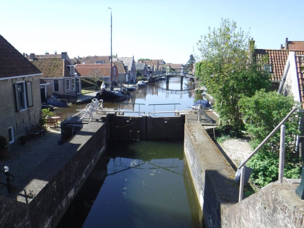
The trail turned to the right and over a bridge next to some residential properties which had their own private moorings and it brought us to the small village of Ossenzijl. We remarked that we must be close to our destination by way of the -zijl at the end of the village name. We weren’t that close but admired our flawed logic later that night in the bar. Just before passing over a little Dutch cantilevered bridge, the trail took us right to follow the narrow path alongside a canal. It was a beautiful area and we decided to stop and have an ice cream. Time was getting on but a little treat was in order to keep us going. A couple of Cornetto’s were purchased from the little canal side shop and we found a small bench with a great view over the canal to sit and enjoy them in the evening sunshine. It is amazing how the simple joy of an ice cream on a warm sunny evening can lift your spirits.

This canal was absolutely lovely and a welcome place to sit for a while with an ice cream.

There appeared to be houses backing right onto the canal along here. What a fantastic place it would be to live. We wound our way along the canal side path, using small cantilevered bridges to get over narrow inlets that went to people’s private moorings at the backs of their houses. The path was not very wide in places but it was great fun to weave along after so much long and straight cycling today. The canal side path ended at Nederland where we re-joined a country lane which took us towards Baarlo and then on towards Blokzijl. We put a few more miles under our belts before we saw a larger town up ahead. We reached a roundabout and to our left was the town sign for Blokzijl. We headed into town and in the centre was a large square water basin where we presumed boats could moor. We were tired so decided to investigate further in the morning.

We located the Hotel Auberge aan het Hof where we were booked in for the night. It also had the best restaurant in town so once again we didn’t have far to go for dinner. After checking in with the lovely and very welcoming host, we had the customary cold beer before we did anything else. Our room was across a court yard on the ground floor, which was welcome to find after the previous climbs up steep staircases with sore legs, and was perfectly comfortable with a large bathroom and loads of hot water coming out of a very powerful shower. It even had a little kitchen with cold drinks in the fridge at no extra cost! We unpacked all of our gear and power showered before heading back across the courtyard for dinner. We had some great food and wine in the restaurant and the hosts were very attentive but not intrusive. We highly recommend staying and eating in the Hotel Auberge aan het Hof if you are in the area. After a slow meal (deliberately – our choice, not theirs!) and a few more drinks we headed back over the courtyard for a good night’s rest. Even though some of the scenery we saw today was quite bland in places, it had been a good day out on the trail.

Day 4 :: Blokijl to Nijkerk

Another day dawned bright blue and clear. Back over the courtyard was a lovely breakfast room. We were lead to our table and a fantastic spread of warm pastries, breads and jam was waiting for us as well as the usual cereals, meats and eggs. We had another fabulous breakfast washed down with copious amounts of coffee, but it was soon time to settle up and bid a fond farewell.

We loaded the bikes, sprayed them with GT-85, and headed back down the narrow street towards the waterside. Blokzijl was originally a port which developed around the peat industry in the 1580’s. An interesting thing to see was a large canon on the harbour side which was apparently used as a warning system against the rising tides rather than to take out invading troops – this was a major problem of course before the Afsluitdijk was built. These days it attracts water sport enthusiasts rather than trade boats. It was a quiet little town with pleasure boats moored in the harbour and people sat around in the early morning sunshine reading novels or chatting with friends; all very tranquil and relaxing.

Today we were heading south west around the bottom of the tour circle to a town called Nijkerk. Due to its position between two waring regions, Nijkerk was regularly the scene of war. In fact, in 1412 the village was completely destroyed. It was rebuild and destroyed several times over the years of conflict, and the name Nijkerk means “New Church” in Dutch as a nod to the number of times the local church was destroyed and rebuilt.

We headed out past the lovely harbour and down the narrow side streets lined with small shops – they don’t seem to go in for pavements in these small Dutch towns – following the route which passed right through Blokzijl and out the other side. The eastern side of the Zuiderzee has been relatively quiet compared to the west from the first part of the tour, but we speculated that it would become more populated again as we headed westward towards Amsterdam over the next couple of days. It would certainly be nice to see more interesting little towns rather than endless flat landscapes.

The endless flat landscape continued before us. We did pass through a couple of small villages – Sint Jansklooster and Poepershoek – and just skirted past the edge Zwartsluis, which means lock by the river Zwarte, which is not dissimilar to “sluice” in English of course, but they were mostly residential as far as we could see. The road up ahead came to an abrupt halt at the water’s edge. We had reached the landing area for the ferry that crosses the Zwarte Water and it was across on the other bank. It was a good excuse to get off the bikes for a while whilst we waited for the ferry to come back across the river for us. Also waiting in the queue was an old vintage truck that was attracting a lot of attention from people waiting to use the ferry. The small chain ferry eventually headed back over the river to pick us up and take us across the short distance to the other side of the river bank.

A little trip on the chain ferry was in order…

The crossing was short; it cost us a couple of Euro for us and the bikes, but it was nice to take a different form of transport for a change and rest the backsides. On reaching the other side we were first off as cyclists and back on the trail. A couple of kilometres down the road and we entered a much more populated town – Genemuiden. The road took us right past a small harbour and through the centre of leafy suburbs, with some large properties set back from the road. This quickly changed to the more typical street side properties lining the road. We reached a small roundabout at the edge of town and headed towards Kampen, which looked to be a much larger town than many we have seen recently. It spans a wider river and we had seen photographs of a really interesting looking bridge that crosses the river through the town that we wanted to see. We should also get there around about lunch time, so lunch in Kampden was the plan.

The route threaded its way through Zandberg along streets and passages between houses and apartments. It very much felt like we were on the outskirts of somewhere bigger than just a town; we must be approaching Kampen. The roads became busier and we saw more people as we approached Kampen. The bridge we had seen in the handbook was up ahead and the trail took us over it to reach the centre of town. The bridge, known as the City Bridge, spanned the Ijssel and connected IJsselmuiden and Kampen. It had a central portion that elevated a whole section of the carriageway upwards keeping it horizontal. To achieve this there was an elaborate pulley system in each corner of the elevated section, with all the pulley wheels painted gold and which were glinting in the mid-day sun. This gave it the appearance of a contraption seen in Willy Wonka’s chocolate factory; quite a sight. Arriving in Kampen also coincided with us passing the 200 mile mark. We were feeling good!

The City Bridge in Kampen – straight out of Willy Wonka’s Chocolate Factory!

We turned right off the bridge to find a good vantage point for a photograph of the fascinating structure and happened across a nice looking (and smelling) fish and chip shop. As it was just about lunch time we thought that a nice portion of fish and chips was on the cards. The “Palingboot het Bottertje” was a fish and chip shop built into a floating pontoon on the river in full view of the City Bridge. We locked up the bikes outside and headed aboard. We decided to dine in and took a table on the terrace so we could enjoy the sunshine and the views over the river. The fish and chips were excellent as were the views. Looking towards the town itself, it was a busy old place. The maps showed the route taking us right into the centre of town. It would be great to see the heart of the place on a busy sunny afternoon.

Full and satisfied on our excellent fish and chips, we reluctantly left the table, saddled up and headed off into town. As expected it was a very busy place with lots of bustling shops, bars and restaurants being enjoyed by lots of people, many sat out with a beer in hand whiling away the afternoon in the sun with their friends. According to Wikipedia, Kampen has one of the best preserved old town centres in the Netherlands, and still today you can see a section of the original ancient city wall and three of the old city gates, as well as numerous old churches. It was a lovely place and great to see so much activity after travelling through many largely deserted villages, open plains, and quiet towns.

The Cellebroederspoort – another impressive town gate leaving Kampen.

Leaving Kampen though one of these fabulous gates, the Cellebroederspoort, took us into more suburban surroundings and though what looked like a University campus, and it was indeed adjacent to Ichthus College which we presumed explained the student like apartments and populace milling around. Still, we were on a smooth, tree-lined cycle path through here so we were having a great time. It continued straight as a die for quite some time, with narrow canals criss-crossing the path before traversing us across a busy motorway and then plunging us back into the country side. This long and true cycle path was called the Cellesbroeksweg and it took us efficiently to and through the small village of De Roskam, and then on and on until a sharp tight turn immediately into the village of Noordeinde, which apparently means north end in Dutch. North end of what exactly, we couldn’t work out, but it was another small settlement near to the Drontermeer, the body of water formed by the presence of the land mass to our right in the Zuiderzee. The narrow road followed the course of the Drontermeer to our right with wide open farm land to our left, and not much else. The hustle and bustle and fish and chips of Kampen felt like a distant memory. A tall levee appeared for a while, blocking what little coastal view we had of the Drontmeer. This same vista continued until we entered Elburg, some 10 miles from Kampen. It felt like we had cycled a lot further; it must have been the extra weight of the fish and chips!

Elberg was a lovely little walled town surrounded by what could only be described as a moat! The old town was rectangular in shape and very reminiscent of the layout of a Roman settlement. Historically, there was evidence found here suggesting that a Roman army had been based in the town which would explain the classic playing-card layout. We entered from its northern most point over a short-arched cobbled bridge. It was a pretty place with tree-lined streets, and cobbled or herringbone patterned bricks covering the road surfaces. We passed along a pedestrianised route which cut right through the centre of town and sat alongside a central narrow canal. It was a traffic-free zone and was obviously the centre of town with numerous cafes and bars lining the route. The straight trail through town re-joined the normal road and cut though an embankment which was the foundation mound of the old long-lost southern city wall. The road cut right through the foundation mound and out to the newer developed areas of the town. We left Elberg and re-joined the cycle path again; turning left and then right to head south once more on a narrow lane.

We passed by a house which had numerous metal structures erected in the front garden along with a sign for 150 euro, so they were being sold as some form of bizarre sculpture for your garden. Some looked pretty good but they really were too big to pack onto the back of our bikes, so we had to pass by on the offer to buy one. All of the houses along this lane were very neat looking with lots of land around them. Very different to those tightly packed together in the nearby towns. After a few hundred yards of cycling along here we came back into the open fields again, and the narrow strip of water between the mainland and the island came back into view to our right. We left the narrow lane to join an even narrower lane that held to the coast, and looking at the map it re-joined the same lane in a mile or two after a bit of a short cut for bikes; nothing wrong with a short cut as long as it’s official.

According to our maps, the next town was Lage Bijssel. Sneeze and you’ll miss it. There were literally two or three properties. One of the two properties was a lovely thatched cottage, and as we passed it admiringly, the town was gone. To be fair, there were a few more properties further up the lane which we presumed were part of the same sprawling town. It was very nice actually with all the space they had around them. They really were not on top of their neighbours, and if you didn’t like someone you could probably avoid them most of the time. We took a right turn past a camp site off the narrow lane and spotted an old windmill just around the corner. We stopped to investigate. The old windmill was called the “Moil De Duif” and there was a neat looking café beneath it. The windmill itself has been restored as an example of a working mill for educational visits as well as general visitors. As it was not that long since lunch time we decided it was too early to stop for more food and drink, so we took some photos instead and headed off on our way.

Another windmill – the fully restored Moil De Duif.

The road we were on passed through lots of varying scenery, lined with tall trees in places, and then past farms with fields of animals by the road side including llamas, and on past large open fields full of crops. The variety was much better to look at. We passed a Europarcs site at Veluwemeer which looked a bit like a UK Centre Parcs but on a smaller scale, and it was right on the back of the river in a fantastic setting. The route started to head back inland again on a cycle path and skirted around Hierden but did take us through some nice leafy suburbs. There was a motorway off to the left which was the busiest road we had seen for some time and meant we were heading to a larger town this time. We cycled underneath a bridge which took the motorway overhead and entered the town of Harderwijk alongside a railway line. This was a much more densely populated town with even a go at some high rise flats, but they only managed to get about five stories high, thank goodness. The path took us around corner after corner down streets between neat rows of houses. This went on for some time and felt like cycling through the suburbs of an English city, although there was no litter, disused mattresses or fridges in people gardens. The housing estate eventually ended and the cycle path tracked alongside a main road. There were some larger businesses along here, like banks, car dealerships and even a cinema. The houses returned again as we headed away from the town centre back out to the suburbs, and they were more traditional on this side of town and presumed it was the older side of Harderwijk as we were slowly heading back towards the coast. This section of coast had a few cafés and ice cream parlours and was probably a hot spot for the locals on a sunny day. It was pretty busy today as the sun was shining, with people milling around enjoying an ice cream and the views over the water. We left the quayside along the Wellenpad cycle path which followed the coastline and joined up with the Zeepad cycle path further along the shore, and then the Waterkeringpad cycle path. We found a massive bike on this part of the route which we thought would look great on the website, so we stopped for some photos.

My, what a big one!

This chain of cycle paths took us along the coast for a good distance, but then abruptly ended in the carpark of the Telstar surfing club. It looked like a smart place so we decided to investigate. It was about time for a little rest, a drink and an ice cream to cool us down. We went inside to explore and took up a table outside on the terrace overlooking the lake and watched some people having a great time surfing whilst we enjoyed a beer and a magnum ice cream. It was a lovely little spot but time was getting on, so back in the saddle, on we went through the car park where the cycle path carried on until it brought us into another, much bigger car park who’s most interesting feature was a McDonald’s Drive Thru – we were not tempted by it! The Palmbosweg took us further southwards, all the time with the river visible beyond the trees to our right. The trees changed to another levee blocking the view, so we were sandwiched between the levee and a busy motorway which was not the best. Eventually the levee lowered and we arrived at a roundabout which we knew was where we needed to leave the route and head into Nijkerk for the night. The road from the roundabout to the hotel was long, straight and fairly busy but as we had come to expect by now, we were safely on a separate cycle path running parallel to the main road. Passing another McDonalds Drive Thru, the town was becoming increasingly more built up. Our stop for the night, the “Golden Tulip Ampt van Nijkerk”, which sounded more like a Chinese restaurant than a hotel, came into view and we cycled wearily up to the front entrance.

It was a good size hotel and looked quite smart. We saw a large number of bike racks out front but they were filled with identical electric bikes. So either there was an electric bike manufacturer’s conference going on, or an electric bike hire company was working from the hotel.

We checked in and were allowed to store our bikes in a lockable shed behind the hotel. So we stored them away for the night and headed to the bar for our customary beer to end the days riding. We sat outside at a table in the hotel court yard to enjoy our beer in the last warmth of the day. Then it was up to the room for a shower and to get ready for dinner.
Tonight we had chosen to visit a local restaurant rather than stay in the hotel. The restaurant was an Argentinian steak restaurant so we were looking forward to some great juicy steaks. It was called Restaurant De Salentein and was about half a mile or so from the hotel. There was a handy pathway over the road from the hotel which cut off a corner and the restaurant was not far from there. It was set in an impressive white moated house with turrets!

The Restaurant Salentein – a must visit if you are in the area.

We both tucked into delicious and very large Argentinian “Tournedos” steaks with all the trimmings, washed down with a bottle or two of Argentinian Malbec “Portillo” from the Mendoza region. It was an absolutely fabulous restaurant. The food was delicious and the service excellent. It is definitely a must visit place to eat if you are in the area. We slowly made our way back to the hotel with full bellies and fuzzy heads, and even found the energy after the walk back to stop off at the hotel bar for a final night cap before bed. Needless to say, we didn’t have too much trouble getting off to sleep after all that.

Day 5 :: Nijkerk to Ijmuiden

The final day of our tour to Holland dawned. Well, it was almost the final day. The actual final day of the trip would be spent driving back from the North East to Cheshire, but today was the final leg of cycling to get us back to the ferry port in Ijmuiden ready for the overnight ferry back to the UK. We therefore had a time scale to work to and could not dawdle too much. We were up early and set off before breakfast was served in the hotel, so we had the intention of finding somewhere enroute to eat once back on the trail. We packed up our gear and paid the bill, retrieving our bikes from their night in the bike shed. We loaded them up and gave them their usual dose of GT-85 to keep them happy. The first part of today’s leg was spent retracing our steps back to the roundabout where we left the trail the night before. We decided against McDonald’s for breakfast and would look for something better in the next hour or so. We arrived back at the roundabout and took a left turn to head west towards Amsterdam. Nijkerk was just about the southernmost point on the tour and from here in we would start to slowly head back up the circle of the Zuiderzeeroute in a north-westerly direction.

Spakenburg was the first town we visited this morning, and it was a lovely looking place albeit very quiet as it was still pretty early. The route took us around the harbour that sits in the middle of the town, surrounded by many shops, bars and restaurants. It looked like a really nice place to be of an evening. After we circumnavigated the town centre we headed back towards the coast passing a nice looking yachting club on the way. It was pretty cold this morning but the blue skies overhead made it a worthwhile price to pay. The road we were on was quiet and hugging the coast again and then the cycle path reappeared as a levee rose from the road level upwards taking the cycle path with it. We followed the cycle path up the incline of the levee and enjoyed an elevated view over the lake glistening in the morning sunshine. Our elevated view point unfortunately only lasted for about half a mile before the path dropped us down again and pushed us back onto the road – it was nice whilst it lasted. The road took us inland and brought us to the town of Eemdijk. We knew that there was a ferry crossing on this section of the route which took us from Eemdijk over to the other bank of the river Eem. We took a right turn off the main road through town to the ferry crossing point; everything was very quiet. We thought as it was early it was likely that the ferry had not started running yet, so we sat down and waited for someone to turn up. And waited. And waited. It dawned on us that this ferry might not be going today. A closer look at the ferry shelter at road side revealed that it did not operate on Sundays. Today was Sunday! A little annoyed with ourselves that we had not checked out the information board sooner, we back tracked to the road junction to consider our options. At that point we noticed that the sign post at the junction that showed the route heading to the ferry terminal also had a second sign indicating the LF23b went on down the main street too. It looked like an alternative route was sign posted for when the ferry was not operating. We consulted the maps and following the diversion would add about 6 miles to our route today, but we had no other choice. We headed south along the road out of Eemdijk following the river Eem, and crossed the river using a bridge in Eembrugge about half way through the diversion. You have to be flexible when travelling such a long way on bikes, and coming across little problems like this and finding a way around it really is all part of the fun.

The terrain on the other side of the river Eem was flat (of course) and consisted largely of wide open fields with narrow streams between. The lanes we were cycling on neatly followed the outlines of the fields. We cycled around the boundaries of a large number of these rectangular fields and on to a very long straight lane. This lane ended abruptly at the side of the water with no bridge to cross, but there was a small floating pontoon which we presumed was the way across. At first we couldn’t quite work out how to get the pontoon over to our side but we quickly worked out that you had to wind a winch that housed a chain which was connected to the pontoon, so we set off winding the handle and saw the pontoon slowly edging back across the water towards us.

DIY ferry trips. Not sure it will catch on…

Once it was with us, we boarded the pontoon and we found a corresponding winch on the pontoon itself so we could slowly wind our way back across the water. We had never been on a self-propelled ferry before so it was quite the experience for both of us. Back on dry land, we headed north again and finally re-joined the route where we should have arrived had the proper ferry actually been operating on a Sunday. The lane continued north and bar a small dog leg, took us over the narrow river Goyersgracht, via a small bridge. This bridge also took us from the region of Utrecht to North Holland. The town of Huizen looked pretty substantial on the map, and after crossing over the busy A27 we skirted around it as we headed back in the direction of the coast. This approach to the coast was through what looked like a building site but after looking on Google maps it was more like a shallow quarry of some kind. There were some interesting looking apartments along here which overlooked the lake. The back of the apartment blocks were angled at approximately 45 degrees and they had individual gardens on each balcony, two on each level for three floors. They looked like fantastic properties and it meant that each apartment had some form of outside garden space no matter what floor you lived on! There were four or five of these apartment blocks along the coastline. Passing through parkland brought us to a large beach front area – the “Strand Zomerkade”. It was mostly apartments lining the promenade, and what few shops we could see surrounding a central square were largely all closed up as it was early May and also Sunday morning, so even though we were thinking we could really do with something to eat there was nowhere open that we could see. We carried on away from the promenade along the cycle path by a main road and hoped we would come across somewhere soon to get something. The road was wide and open, and lined with trees. It took us past an inordinate number of car dealerships and down to a little harbour. We spotted a café open to our left and so pulled up quickly to see if we could get something to eat and drink. We had already completed 25 miles this morning and that was running on empty. The café – Restaurant De Haven van Huizen – was set back from the harbour but it had a separate under cover seating area right by the side of the water, so we found a free table and sat to see what was on offer. All they had were cakes and drinks, so we ordered a couple of apple pies and accompanying cappuccinos and it would have to see us through until lunch time. It was very good apple pie, so we ate it slowly to savour it and enjoy it, but also to prolong our rest by the picturesque harbour side.

After we had finished our breakfast we climbed back on our bikes and headed along the side of the pretty harbour. We were cycling past a large car park to our right when we realised that we had lost the route signs. We pulled to a halt and checked where we were against the route map. The route had taken a sharp right hand turn through the large car park which we had missed as we were waxing lyrical about how nice the apple pie had been for breakfast. We retraced our steps and spotted where the route had deviated off to the right, so off we went through the car park and were back on track. Our trip into a car park didn’t last long and with a couple of hundred yards we were back on a dirt cycle path which headed through some trees and was slowly taking us back to the coast. Cycling through the forest was really nice and a change from the open areas found on a lot of this trip. It was quite cool but refreshing as we speeded along the smooth pathway. The narrow cycle path eventually connected up to a wider roadway but still kept us in the heart of the forest. Riding through here was fantastic, surrounded by large trees and dappled sunlight, and with all the wildlife singing around you we would even go to say it was one of the nicest parts of the route. Our trip through the forest went on for a good couple of miles. As the forest was thinning out, the surface beneath our tyres changed from dirt track to tarmac as the route headed south and past some very grand properties. We noted one gate in particular – as it was in English – had a coat of arms with two red dragons, one either side of it on the gates, and the words “HOUSE OF DREAMS – WHAT DREAMS MAY COME” beneath the coat of arms in huge letters. We didn’t know what went on in there, but hoped it wasn’t the headquarters for the local swingers association!

The sign posts indicated a left turn up ahead which took us off the road and onto a very narrow dirt track, which was more our kind of cycling. The track took us completely out of the forest and along field boundaries with wide open spaces around us. We felt very exposed after the last couple of miles cycling through the forest. We kept on this narrow track passing beneath the busy A321 motorway and then up ahead we saw an incredible looking moated town with fortified walls. It was like something out of a movie. The path wound its way around the surrounding water showing off the walls from all angles until it brought us over a wooden bridge and through a gated entrance – the Utrechtse Poort – into the town itself. The impressive looking town was Naarden. According to Wikipedia, it is an example of a moated star fort and was granted city rights in 1300. Interestingly, because of its distinctive shape from the sky, it was used during world war two as a rallying point for allied aircraft returning to England from raids over Germany.

Utrechtse Poort in Naarden. A very picturesque town.

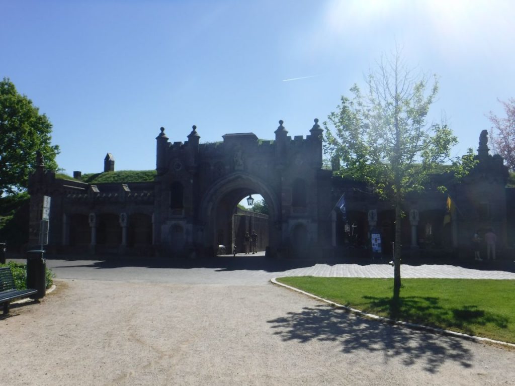
On the inside once through the gateway we were greeted by a wide open courtyard with a lovely fountain as its centrepiece. We stopped for a little look around and to sit for a while and admire the fascinating scene all around us. It was a pretty interesting place. The cycle route took the road which circumnavigated the town, following closely around the perimeter wall. All of the houses were arranged neatly around wide road mostly lined with trees and bushes and then the cycle way narrowed as it took us towards the northern side of the town. There was no impressive gateway in the northern wall like there was on the way in but the route took us over a causeway to cross the moat, and looking back at Naarden gave a fantastic view of the star shaped wall structure.

Very quickly the route headed off the road again and back onto a dedicated cycle path named the Zuiderzeepad. The Zuiderzeepad by-passed the new part of Naarden outside of the old town walls and underneath the A1 before changing its name to the Schelpwag as it took us across what appeared to be a series of boggy looking fields but which turned out to be a golf course – the Golfbaarn Naarderbos. We passed underneath the busy A6 before finding ourselves in the town of Muiderberg where we caught site of the lake again. The route through Muiderberg was literally all through a housing estate, until we hit the Dijkweg which was in a much more pleasant green and leafy area. The Dijkweg carried on alongside the lake, although it as not visible due to another levee blocking the view. It was very nice cycling as the path was smooth and the view to the left open and fair. This lovely long ride continued and ended up canal side as we neared Muiden. We crossed the canal via a small road bridge and entered the town on its eastern side. Mudien was a lovely little town sat across three inland spurs of the Ijmeer. Around the inland waterways were numerous shops and cafes; it was quite a buzzing little town. The first bridge to cross a waterway was open as we approached, so we were sat in a busy queue for several minutes while the water traffic passed by and the bridge was reopened. The other bridges through town were all closed and we made good progress with the road then following the riverside for a distance. The river became progressively wider as we cycled west, and when we finally came to cross to its north bank, it was via a pretty substantial bridge. Once through an industrial area, we picked up a cycle path again headed back towards the lake and then turned northwest alongside the Amsterdam-rijnkanaal heading back to Amsterdam. We were on the north bank of the wide river at this point, and so the trail took us over a lovely modern sweeping bridge, the Nesciobrug, to bring us back over to the south side. We free-wheeled down the gentle slope off the Nesciobrug bridge and back on the river side cycle path, but this time on the south bank. This followed the river northwards on a narrow causeway before we came to the road bridge where we had picked up the official route 5 days ago. The official route was complete, but for us the tour would only end at the ferry port in Ijmuiden.

All that was left now was for us to retrace our steps back through Amsterdam and then out along the spur to the port. We decided that we would have a late lunch at the Chinese restaurant we passed on the way out of Amsterdam, the “Happy Happy Joy Joy”. We got there in good time and found a table outside in the sunshine, before ordering a couple of noodle dishes and beers to wash it all down. The food was really good, and we wished we had had time to stop on the way out to enjoy it again.

We finally got to eat in the “Happy Happy Joy Joy” restaurant. It was worth the wait!

After our late lunch we back tracked across Amsterdam enjoying the sights and sounds as we went. The spur back towards Ijmuiden saw us pass the 300 mile mark, smashing our previous record for distance cycled on a BGB tour.

300 miles and we were almost there.

From there we were kept on the cycle path by the river link from the North sea to Amsterdam until we arrived back in the small port town of Ijmuiden. Our ship was there waiting for us, although we were in plenty of time this time around. We joined the queue of other cyclists waiting to be allowed to board. After what seemed like an inordinate amount of time, the port gates opened and following passport and ticket checks we were allowed to board and stow our bikes in the hold. We quickly located our cabin and dumped all of the gear before heading up for a beer. As the sun was shining we went up to the open air bar on the top deck of the ship and ordered a couple of cans of Fosters served in plastic cups – very classy! Half way through our “refreshing” beverages the ship’s horn sounded loudly signalling that it was time to depart and head back over the North Sea. We stayed up on the top deck for quite a while to watch the Dutch coastline slowly pass us by and then disappear from view, before heading back down for a shower and to change ready for dinner.

We had booked a table in the “posh” restaurant again for dinner. We both chose different dishes for the return trip, and the food in the North Sea Bistro restaurant was equally as good as we had remembered it on the trip out. Once we had enjoyed our meal and finished a nice bottle wine, we headed up to the lounge bar for another beer or two and to see if there was any good entertainment going on this evening. We settled on a guy taking song requests and singing along to his guitar, and he was absolutely brilliant. We ended up watching him all night and probably drinking a bit more than we should have done. We went to bed pretty late after he had finished his set and fell sound asleep to the slow rocking of the ship.

Day 6 :: South Shields to Cheshire

We woke up to an announcement that breakfast was being served in the self-service restaurant. We showered, dressed into our civvies, and re-packed our gear. We were in no particular rush to get up to the restaurant as we knew what was on offer would not be great. We headed up there as the ferry docked into the Port of Tyne in South Shields. There was plenty of time to leave the ship but human nature is to panic and rush to get off. This meant that the restaurant was emptying quickly and was quieter, so we helped ourselves to the least dried up breakfast items we could find, and sat at a window table overlooking the port. The Port of Tyne was very industrial and areas of the port that were not in use lay largely derelict and were not pretty. All rather shabby. After breakfast we checked out of the cabin and retrieved our bikes. We cycled off the ship and through the UK Border Force check point. The car was parked within a hundred yards of the Border Patrol kiosk, so it was a quick and simple job to relocate the car. Bikes reloaded into the back of the car along with all of our luggage, and we hit the road for the trip back down to Cheshire.

It had been a good tour. Holland was really nice and flat so not too trying on the legs – the steepest parts of the trip were climbing the stairs! We had completed a good distance, breaking all previous records, and saw some interesting places and met some lovely people. The weather was also remained generally good for the whole week which is all we can ask for.

We would certainly recommend the Zuiderzeeroute, and especially so if you don’t like too much climbing. The Dutch are very welcoming and their English is impeccable which makes things much easier for ignorant Brits like us. Get on over there and enjoy their fabulous country.

Until next time.

The Boys.

Pirinexus 2017

Day 1 – Girona Airport to Olot.

The Pyrenees mountain range sits neatly on the border between France and Spain. Pirinexus is a long distance cycle route that visits both countries and so it is obvious that you will have to cycle over the mountains to get from one side to the other. Well, it’s obvious now isn’t it?

The attraction of Pirinexus to us was the speculation of vistas from mountain to sea. Somehow it didn’t seem obvious when planning the trip that we might have to climb those mountains. It also became apparent that my maths is very rusty. I think I calculated about 3,000 feet of climbing over the course of the journey. It was that magical figure of 3,000 feet that I sold the trip to Mike on. We were both convinced by the figure. I don’t think Mike trusts me anymore to make these types of calculations; in fact I don’t trust myself either.

We were all packed and ready to go on a pleasant Cheshire morning. It was a little too early for our liking, but it was an early flight to get us to the start of our journey in time for a decent amount of mileage in the saddle for day one. We planned to cycle to Olot by this evening which was calculated at thirty or so miles. Not too far for the first day which would also involve flying out to Spain and rebuilding our bikes before we could get underway along the route.

We arrived at Manchester Airport bright and early and checked in our luggage and bikes.

At the airport and ready to go!

The airport was fairly busy but we’d bought some FastTrack security tickets so everything went smoothly as we passed through security and into the departure lounge. We headed off to find a café for a full English breakfast – the carb and protein loading had begun.

We boarded our flight to Girona and it departed early. The flight over to Spain was great with no problems or delays; in fact we arrived 30 minutes early into Girona. Being fairly early in the year, the airport which would normally be heaving with families craving the sun and poolside rest on the Costa Brava was quiet. We picked up all of our luggage including the bike bags (undamaged!) within minutes and grabbed ourselves a taxi to the Sallés Airport hotel about 1.5 km from the airport. They had very kindly agreed to store our luggage at their hotel until our return five days later. This was a crucial element to our trip and without their help storing our luggage we would not have been able to do the ride. So a HUGE thanks to the hotel for doing this for us.

The tour start and finish point – the airport hotel.

The first hour was spent unpacking and rebuilding our bikes and then, once changed into the BGB team shirts and Assos cream applied, we were ready for the off. It was hot outside; very hot. When training for a ride like this in the UK, the heat is a factor you cannot really prepare for. It took us by surprise and was a sign of things to come. It was 11.45am but with only 30 miles to go today, we planned to arrive into Olot during the early evening.  With plenty of water on board the bikes and copious sun screen slapped on, we were off. The 2017 big ride had begun.

Ready to start the tour in the sunshine.

Pirinexus is a circular route which makes life a lot easier for travelling to the start / end of the ride. Girona airport was not directly on the route but it was close by, so we had to cycle along a fairly busy 7.3km long link road which intercepted the route. It wasn’t a pleasant start to the trip as the road carried a lot of heavy goods traffic along it. Spanish roads, in common with other roads in Europe, had a wide lane at the side which made for an unofficial cycle lane. It vanished in places and pushed you back into the main flow of traffic, but for the most we managed to keep in these lanes and onto the odd road side dirt cycle path. This road passed through Riudellots de la Selva and Campllong before we hit the roundabout that intercepted the official route. The roundabout rather bizarrely contained huge corks! From here we could leave the busy road and start the official Pirinexus Route.

Cork island – where our modified trail meets Pirinexus.

After a little poking around (okay we took the wrong turning – not a great start), we located the cycle route alongside some farm buildings just off the roundabout and off we went along quiet off road tracks – heaven! It was a rather unassuming starting post but as it is a circular route there is no official start as such. Anyway, we had adopted the hotel as the unofficial start and finish post so it wasn’t a problem.

If you read around forums and web sites about Pirinexus, you quickly learn that the signage in this western part of the route is not always the best. We also found this to be the case. Within the first five minutes travelling along the route we arrived at a junction with four possible ways to go – well three as we had come along one of them – but no signs to tell you which way to take. We did have a Garmin GPS on one of the bikes but for some reason we couldn’t figure out, the downloaded Pirinexus route only showed up as small sections and miles off route! There must have been some corruption in the data files, so whereas on previous rides it was invaluable, it proved pretty useless to us this year. We’d have to rely on the trail-side signs and maps alone.

We had the official paper maps that we had downloaded from the Pirinexus web site and printed out so all we could do was relate these paper maps to Google Maps and try to work out where we were and where we were supposed to be going. After a little umming an arring we made an educated decision which luckily proved to be the right decision. The trail joined an old disused narrow gauge railway behind a farm house that was hiding the trail from view. The surface was compacted dirt but was firm enough to travel along at a fair speed. It was very dry and dusty though and we ended traveling through clouds of dust which found its way into every nook and cranny for a lot of the day.

We stopped for a late lunch at the Parc Café on a Science Park in La Creueta that sat directly on the route. Spanish sausage and potato followed by a delicious apple tart with caramel sauce all washed down with a couple of full-fat Cokes was just what we needed to refuel before we continued on towards Olot. Every so often we saw signs which also told you the distance to go to various places, including Olot. It seemed to be a lot further away than we had calculated. It was whilst discussing this discrepancy in the distances that it dawned on us why Olot was so far away. Our initial route calculations had us starting in the centre of Girona. Girona Airport is some way from Girona itself as most major airports are, so we had to cycle to Olot from the airport and not from Girona city centre – another school boy error in my calculations. So rather than it being a short day of cycling, it would be a lot further than we had planned. We weren’t even in Girona yet. It would be a late arrival into Olot this evening!

After our delicious local lunch we headed back along the trail and quickly hit the outskirts of Girona. The trail wound this way and that through housing estates filled with homes painted in differing pastel shades of terracotta, and along quiet roads until it headed through the busy narrow streets of Girona itself. It was a lovely looking town with grand buildings and squares full of cafes and people chatting over small cups of coffee. We took the opportunity to get some cash out of a cash machine and continued to follow the trail along the banks of the river Onyar and across a busy roundabout before heading into a local park. The trail followed some wide pathways through the Parc de la Devesa with its shaded trees which offered some welcome cool air. We passed over another branch of the river and along some more dusty tracks. The trail passed between what looked like simple allotments growing various fruit and veg.

We got a little disorientated by the side of the A-2 motorway as there were a couple of tracks to follow, so we went back and forth through a tunnel under the motorway a couple of times until we got our bearings. The air in the tunnel was cool so we cycled slowly through and enjoyed a bit of a cool down. We pressed on along the dusty tracks alongside field after field of the same crop, which looked possibly like apricots or some similar fruit.

We followed the off-road trail for a good long while and the signage although sparse did seem more accurate than it had been in the first part of the trail. It headed through forests of tall birch trees with their silvery trunks standing parallel in neat rows, and alongside fields with what we took to be sweet corn plants early on in their growth cycle, simply just from the appearance and shape of the green plants.

The trail re-joined the N-141e. The road was straight and smooth and, most importantly, quiet of traffic. The next town we arrived at was Bescanó where the trail left the main road just before the town border and skirted around the top of town before dropping back to the road where it ran alongside but not on it. In the distance we could see mountains starting to rise up. There was a distinctive flat topped mountain dead ahead which Mike likened to the summit of Pen-y-ghent, one of the three mountains that make up the Yorkshire three peaks back in the UK. We talked about how this might have formed in the ice age – being a geologist, Mike knows a lot of interesting facts about things like this. Our dirt track kept on alongside the main road weaving into and out of small areas of trees and dappled shade, which was a welcome relief from the hot sun. The dirt surface was generally flat and straight, and was really a joy to cycle along. It kept on going, passing through Vilanna and Angleś before the road was renamed the C-63 and we parted company from it at a roundabout, heading down a palm tree lined cycle track. This track put us back on the narrow gauge railway, evident by the steel bridgework still present and the occasional platform edge peeping out from beneath the overgrown bushes. It was getting fairly late in the day by this point, about 7.30pm and we were getting a little concerned about what time we would arrive into Olot following the slight miscalculation. We had to get there as we had a room booked in a hotel. We reckoned about two hours of light were left before it went dark. That great British resolve of heads down and get on with it was deployed and so early in the ride too.

On the trail towards Olot.

The track on the narrow gauge railway wound through and around fields, but always keeping close to the road. From time to time we got glimpses of it from between the trees and houses. The track continued and then took a sharp left, down a hill and over a bridge, and on the other side of the bridge it turned sharp right clearly heading back up towards its reunion with the main road. Right on the corner of this bend was a bar – Bar and Restaurant La Parada. It was like an oasis as it came into our vision. There were a few tables and chairs arranged neatly outside the bar, one occupied by some locals engaged in a very gesticulate conversation. We saw an empty table with a large sign offering Estrella beer hung above it. It pretty much had our name on it so we took that as a hint that despite the latening hour we had to stop and order two cold beers.

They tasted so good after five hours of cycling in the dusty heat. We started chatting with a man sat with the other locals. He heard us speaking English and started to chat to us in perfect English. Just a few days before we started our ride, a lone suicide bomber detonated a device at the end of the Ariana Grande concert in the Manchester Arena killing 23 adults and children, and injuring 119 others, so conversation quickly turned to this and the horrors it brought. He’d lived in Croydon near to London for a number of years before returning to his home town when he retired (which explained his good command of the English language). We talked about England and Spain and how he liked British people and our way of life, but the warmth of his home town and cheaper cost of living brought him back. We were reluctant to leave this lovely little corner of Spain but knew we were still some way off our destination, so we resisted ordering another couple of cold beers and bid them all farewell and headed off back long the trail. The trail went down and under the road to cross to the other side and then a short sharp climb brought us back up alongside it as we had expected. About 500 yards further along, the trail suddenly crossed the road and headed back on a tangent along the narrow gauge railway bed. There were a few acute twists and turns in the track, so unless the narrow gauge trains were very agile, there were some clear deviations from the original track.  The track was also on a constant gradient climb. Not steep – one in fifty at the most – but relentless. The next 20 miles saw us carry on along the narrow gauge railway track with the climb continuing pretty much all the way. The trail went along a cutting through the hillside with heavy trees along both sides obscuring the view for much of the way. All we could see for most of this section were occasional huge vertical drops off the side of the old bridges, most with streams or rivers running underneath them.

We passed through several towns along the way: Amer, Les Planes d’ Hostoles, and Sant Feliu de Pallerols.  This section was exhausting as the climb was always there and the legs tired. I had picked up cramp in my right calf so the stops were becoming more frequent to stretch tired muscles and take on board water and glucose. Our water supply was becoming low; we had filled two water bottles each but that was proving not to be enough in the heat. A lesson learned for the rest of the trip. From here in we filled both of our water bottles and bought an additional 1.5 litres each to carry in the panniers – extra weight but well worth carrying.  Eventually we left the dusty railway track to re-join the road at Sant Esteve d’en Bas.

We were getting close to Olot but it was also getting dark. We spotted a petrol station at the side of the road which had a soft drinks vending machine out in front and some aluminium tables and chairs set out next to it. We were both very tired by now and needed a rest and a drink. What was left of our water was warm and dusty tasting, so to be able to buy a couple of ice cold Cokes was a joy to behold. We sat on the garden furniture sipping our Cokes, watching the sun set on a beautiful evening. Sitting outside a petrol station by the side of the road was not quite what we had hoped for our first evening in Spain, but it would have to do.

Night was closing in fast!

By the time we had finished our drinks and rested our tired muscles, it was almost dark. We consulted the maps and made an executive decision to follow the C-152 straight into Olot. It would be busier but we were concerned that following the trail in the dark could result in us damaging our bikes, or more importantly ourselves if we hit a rut in the dark. We donned our “High-Viz” jackets, put the lights onto our bikes and headed off along the main road towards Olot. Being a smooth tarmac surface meant we made good progress along the road, and the houses, shops and restaurants of Olot soon came into view after about 30 minutes of cycling.

We quickly located the Hotel Borrell in town and checked in. They had a huge underground garage in which to safely store our bikes, so we unloaded them and locked them together before hurrying upstairs to our room to grab quick shower. It was 9.45pm when we checked in so we were hugely behind schedule. Today’s 30 miler had turned into a 50 miler because of a slight (ahem!) miscalculation on my part. We went out to seek food. Every restaurant we tried to get into said they were closed so we gave up and settled for a take away. I took on board some salt to try to combat the cramps in my right calf – gross but seemed to do the trick as it did not return. Thank goodness they sold beer in the burger joint. We gobbled down our disappointing but tasty enough dinner of a “special” cheese burger and fries, and headed back to the hotel for a well-deserved night’s sleep. We had to do it all again tomorrow with 43 miles planned which would include the climb up into and over the Pyrenees and down in to France.

Day 2 – Olot to Prats-de-Mollo-la-Preste.

We awoke to another (predictably) glorious day. Continental breakfast is not really what you want when cycle touring. You need the carbs and protein to keep you going, but it was all that was on offer so we ate as much as we could to keep us going until we could find some meat for lunch, and then loaded up and lubricated our trusty bikes ready for the day’s challenges.

Sun cream applied, we cycled back to the main road we had arrived in on and located the route through Olot. It took a left turn around a pleasant looking park where we spotted a supermarket to stock up on water and snacks. With extra water loaded into our bags, we headed off along the road which quickly turned into a cycle path by the road side, and then we were back onto the main road through the back of town. This road took a sharp left and then started to climb. Climbing was to be the theme for much of the day.

The slow climb out of Olot.

We tried different strategies to manage the constant long and grinding climb. The best way we found to cope was to break it down into small sections, taking a few minutes break for rest, water and a natter every few kilometres. The road itself was just that – a seemingly endless strip of tarmac – but the views that we came across were ever changing and spectacular as we wound our way higher up into the mountains.

What a view and we have only just started.

After two hours of stopping and starting – did we mention that we REALLY don’t like climbing? – we reached the top of the Coll de Coubet at 1010m (3314 feet); we felt very chuffed with ourselves. The road then dropped down before starting to climb again (why, oh why?!) using our “Oh So Special” technique. We passed several cyclists also cycling up the mountain, some struggling as we were and others on electric bikes which appeared to take all of the effort out of the climb. We spotted a couple of cyclists at the side of the road struggling with something. We stopped to offer our help and one of the cyclists had managed to snap his chain. They had wondered if we had a chain link removing tool to allow them to reconnect it together after removing the broken link. Unfortunately we did not have one – we had left it at home! We tried to help without success so offered them our best wishes and left them to it.

We kept on going up and this time we climbed to top of the Coll de Santigosa at 1064m (3491 feet). We’d done it. We’d got to the top and it was now downhill all the way.

Coll de Santigosa.

The cyclist with the broken chain passed us on the way down, speeding away. At first we thought that they had managed to mend the chain but after closer inspection it became apparent that he had taken the chain off his bike and was being powered by gravity alone. We hoped for his sake that the road kept on going down all the way to the nearest bike shop.

It did, and we freewheeled down and into the town of Sant Joan de les Abadesses where we found a little road side café called Bar Clave which sat opposite a lovely old ruined chapel. We sat and rested at the outdoor tables of the Bar Clave and ordered some cheese burgers and fries. The burgers came without any buns – more like steak haché – but with lots of cheese and caramelised onion so we settled for that, and they were very tasty. They also gave us a bowl of olives whilst we were waiting, which were the nicest marinated olives I have ever eaten. I should have asked the owner what they were called so I could have got some.

Lunch time.

We sat there in the sun, bellies full of protein, basking in our day’s achievement and it was only lunch time. It dawned on us at that point that it was actually rather early in the day to have completed the hardest part of the days ride and the slow realisation crept over us that maybe we were not, in fact, finished. We sheepishly changed our map over to the next section of the trail, and much to our horror we discovered what we had feared. We had not actually climbed over the Pyrenees yet and we still had a long way to go up before we went over and down into France. Our celebrations were rather premature and short-lived. We needed to stop doing this to ourselves!

We settled our bill for lunch and picked up the trail again through town and over the river Ter. There was quite an iconic bridge over the river which appears on the Pirinexus web site, so Mike offered to climb to the top for a photo – as if he hadn’t done enough climbing already today!

Unusual looking bridge. That’s Mike right at the top!

The trail turned right after the river crossing and up a road which climbed steeply. It levelled out as it passed an old railway station on our left and then we re-joined the narrow gauge railway bed as it headed out of town. This climbed along the line of the valley and soon we were high up over the town. The trail went along country tracks and narrow trails before dropping down again to follow the river Ter through heavily wooded areas and past farms along the valley floor. It was along this section that we must have taken a wrong turning somewhere, although we did not know it at the time. The signage seemed to dry up along this section but we were finding that not to be too uncommon, so we used our maps and assumed we knew where we were as there didn’t seem to be many alternatives. The trail wound its way around the valley floor until it stopped dead at the side of a river. We could see the river was shallower in this area with a natural pebble and stone weir visible under the water’s surface, and we could see the road continuing over on the other bank of the river. This had to be the way as we could see no other way around it.

You sure this is the way?

So off came the shoes and socks, and we proceeded to cross the river with our bikes. The water was freezing although with the weather being so warm we didn’t mind that so much. There was a fairly strong undercurrent which tried wrestled the bikes out of our hands and the rocks underfoot were slimy and slippy. The water got deeper and I nearly lost my footing and the bike several times during the crossing.

Should it be this deep, Mike?!

We reached the other side with all of our possessions intact although the panniers did take a proper soaking so we were not sure how well the gear inside would have fared. A quick check and all was well. The panniers had not let us down. The Pirinexus web site mentions river crossings at various points along the route so we assumed that this was just one of them. We did, however, feel that it was a bit harsh and actually quite dangerous after the event. We continued along the track on the other side of the river until we got to a junction. There was a very dodgy looking rope bridge to our left which Mike started to climb up to get a higher vantage point to look for any signs, but he quickly changed his mind and came back as it swayed, creaked and groaned beneath him. Ahead the trail disappeared along a narrow and clearly unused pathway, and to the right it disappeared up a hill towards some houses. There were no signs anywhere. At this point we got very suspicious that we were not actually in the right place and we may have just crossed a fairly dangerous river unnecessarily! We climbed up the pathway towards the houses as it was the best option we could see until we came to the road, and then we looked at Google Maps which showed us that we were in fact quite some way off the route and we had indeed crossed the river in the wrong place. The official trail was still on the other side of the river! We must have taken a wrong turn some way back and then just got hopelessly lost. We could see from Google Maps that if we continued along the road we had arrived at, we would intercept the trail in a couple of miles and get back on the proper route.

So a little unsettled by our error, we cycle off again sticking to the road and followed it until as we crossed a roundabout and it changed from the N-260 to the C-38, we saw an opening in the hedge line and a reassuring Pirinexus sign on our left hand side. This was where we should have come out from the river, presumably after taking a much shallower and safer crossing. I looked at the crossing we should have taken over the river on Google Maps later in the evening, and our route would have taken us over a perfectly sensible and dry bridge. Ah, well; it adds to the richness of the trip. We’d survived the dangerous crossing of the torrential river Ter – okay, perhaps that is a bit of an exaggeration but that’s what these tales are all about. Onward we pressed as the official route joined the road we were already cycling along.

The road was fairly quiet and had one of those wide lanes at the side which is just perfect for cycling along. We arrived at the town of Sant Pau de Segúries and the trail left the main road onto quieter parallel local roads, taking us past sleepy houses and farms before taking a sharp right and then a left to re-join the main road. We followed the main road again but only for a short stretch before the trail turned off it and up a very steep section paved in grooved concrete. We got off and pushed up this section as it really was too steep to cycle up it on our weary legs. Thankfully, it did not last long before it levelled out beneath a viaduct which we presumed carried the ever-present narrow gauge railway bed. This area of the trail took us through deep woods of oak trees which was much cooler and was welcome relief from the heat of the sun. It wound its way along the side of a hill and entered the back of a camp site – the Camping Vall de Camprodon. It looked like a nice camp site with a sizeable outdoor pool which would have been perfect for a cooling dip – but we had no time to engage in such activities. We left the campsite through its main entrance and re-joined the main road once again. The traffic was still light, so this was no hardship and made for some timely cycling. The road went through Camprodon itself (not surprisingly) and out the other side before it started to climb again as it headed towards Molló. The route wound its way back and forth to minimise the gradient, although it was still hard work on tired legs. It was approaching 5pm when we got to the turning for Molló and had ideas of finding a little road side café in which to enjoy a refreshing beer. We arrived at the roundabout signposted to Molló and we could see the town not too far away, but it was uphill and not on our route. We decided that any unnecessary climbing was, well, very unnecessary so an executive decision was made not to visit the centre of Molló but to press on along the route and hope we find a similar café further along.

Too far up even for a beer!

We carried on and away from Molló up the climbing road. We cycled past a sign for the Restaurant Panoramix, and we thought this is it – “Beer o’clock”. It promised a bar and restaurant nearby for all to use. Great, but when we found it about 500 yards further up the road, it was closed. Not great, but all was not lost as next door to the restaurant and bar was a petrol station which boasted that it was open for business 24 hours a day. Cold drinks and snacks would soon be ours. We cycled over to it and it too was closed! We were gutted but were not beaten. We kept on going up and up into the mountains. At least the scenery was beautiful. We made good progress and stopped for a drink of warm water and an oaty fruit bar by the road side. Not quite the cool refreshing beer we had fantasised about but it’s all we had. We had travelled quite some way from Molló in what felt like a relatively short period of time.

Beautiful views.

We climbed and stopped and then climbed again as we progressed along the winding mountain road. Every kilometre or so there was a small Pirinexus sign by the road side which told us how far to the top. There was about 10 kilometres to go to the top. It also showed the gradient of the road over the next kilometre between the sign posts. Each sign seemed to show the gradient getting steeper and steeper, and it wasn’t lying! We got off and pushed in a few sections as our legs were very tired having been on the road now for over 8 hours, with many of those hours spent climbing. After a further half an hour of ascent we reached the signpost for the “Coll d’Ares”. This really was the top of the Pyrenees part of Pirinexus at 1513 meters (4964 feet). We felt overjoyed and shattered after such a long day of climbing. We celebrated with some more warm water and orange flavoured glucose sweets before cycling the final small section over the top of the Coll. It took us past the old border control building which was now a (of course closed) café, before the road started to drop away down. It is in this section that we left Spain and entered France. There was nothing more than a signpost and a change in the colour of the road tarmac to denote our arrival into a new country, but we felt a sense of relief that we had finally climbed over the mountain range and could enjoy some downhill cycling.

Another country.

It was almost 7pm and the sun was quickly disappearing behind the mountains. Being so high up in the mountains, the temperature dropped quickly, so we donned our jackets and helmet under-layers to keep warm. This section was the final run down into Pratts-de-Mollo-la-Preste which was our destination for this second day of cycling. It was road all the way and we freewheeled most of it. After all our efforts cycling uphill today, it was divine to get some free mileage in. The road surface had been top dressed with small stones fairly recently so we had to take care on the way down for fear of hitting a pile of loose stones and coming a cropper on one of the tighter corners as the road zig-zagged its way down the mountain side to the valley floor.

The road wound its way down the steep mountain side for quite some distance before finally bringing us right into the centre of Pratts-de-Mollo-la-Preste. We were staying at the Hotel Bellevue. We stopped at a roundabout in the centre of town to contemplate where the hotel could be, and quickly realised that it was dead ahead. We could not have found a hotel more on the route. Perfect. We cycled up to the hotel which had some tables and chairs set out on a covered raised balcony area giving lovely views over the town below. We sat down and ordered the two large beers that we had promised ourselves a few long hours ago. After a relaxing half hour supping our beers and enjoying the warm evening, the lady serving us asked if we were staying. We told her that we had booked into her hotel and would like dinner. She advised that dinner stopped at 9pm so we had to cut short our chill-out time to grab showers and get changed before the restaurant shut. Before we left the UK we checked with each hotel that they could safely and securely store our bikes overnight. Our choice of accommodation was based on this as well as having a close proximity to the route. We asked the hotel receptionist where we could store our bikes and she gave us a blank look. She said there was a car park in the field behind the hotel. I went to have a look and all I found was an open field without anything to secure the bikes to or anything to stop people walking into the car park and pinching the bikes or equipment off them. We were not amused because if anything were to happen to our bikes then the trip would be over. We decided to strip everything we could off the bikes and padlock them to the railings outside the front of the hotel; they were heavy and firmly fixed wrought iron railings so would provide a solid anchor to attach them too for the night. Not ideal but it is all we had to which we could secure the bikes. In my experience, the décor in France is always more rustic than other countries and this hotel was no different. It was all rather small and old fashioned compared to the spacious modern room we had stayed in the previous night in Olot. We grabbed quick showers in the smallest bathroom ever known to man and then it was straight down to the restaurant for dinner at bang on 9pm.

Our digs for the night.

The TripAdvisor reviews for places to eat in Pratts-de-Mollo-la-Preste gave the Hotel Bellevue restaurant, the “Bellavista”, as the #1 place to eat, so we had high expectations. I am glad to say that we were not disappointed. We had booked a Half Board package so we did not get to choose from the full menu, but even so, what they served was delicious and to a fine dining standard with great presentation and flavours. We had a rich cheese and bacon tart to begin with (bit like a quiche), followed by a veal dish – “Vedella des Pyrénées”, accompanied by local vegetables and a beautiful sauce. There was a toffee sponge pudding for dessert, all washed down with a lovely bottle of local white wine.  We retired to the bar for a nightcap and then off to bed for some well-earned rest. We were exhausted after such a lot of climbing and still had three days of cycling ahead of us, but we were full and happy.

Day 3:  Pratts-de-Mollo-la-Preste to La Jonquera.

Another warm and clear blue skies morning greeted us, and the bikes had survived the night unscathed strapped to their wrought iron fence. We headed down to the breakfast room to fill up on the usual fayre of croissants and cakes before packing up the gear and loading the bikes ready for the third day of our adventure. Today’s destination was La Jonquera some 43.5 miles away. Having done a lot of climbing yesterday, we were hoping for an easier time in the saddle with some downhill sections.

We found the local supermarket which was quite hidden away, being set back from the road and tucked between two other buildings. We bought our daily stash of water and oaty fruit bars before heading off downhill – a good start to the day. The route followed the D115 out of Pratts-de-Mollo-la-Preste and wound its way alongside and over the river Ter, criss-crossing back and forth. There was some traffic on the road but being away from any big towns, it was fairly light and bar one idiotic motorcyclist cutting us up, the drivers were mainly all courteous and careful. We passed through several towns as we followed the road – Le Tech, Can Partére, Arles-sur-Tech and El Calciner to name a few. The trail parted from the road in El Carciner and turned into a much more enjoyable dirt track which sat on the old narrow railway bed; we were seeing a lot of this narrow gauge railway on this tour. The course followed the road and the river but at least we were away from any traffic. All the while we followed the trail there were great views to our right down towards the valley floor. It is on this section that we passed the 100 mile mark. We followed the trail over a very high bridge and then through a tunnel at La Forge before passing over an unusual covered steel bridge crossing the river Ter once again in Le Pont De Reynes.

Unusual bridge at Le Pont De Reynes.

So far today we have been steadily heading down hill, which was a welcome relief after yesterday. We knew we had to get back into Spain at some point today as that is where our destination lay, and that of course meant we had to cross the Pyrenees again at some stage. From the route profiles shown on the official web site, we knew the climbing was not as severe as yesterday but we still anticipated quite a lot of effort would be needed later in the day. We tried not to think about it too much just yet and pressed on.

We passed through the sprawling town of Cabanassa which quickly merged with La Pont due Ceret and La Porte Du Vallespir before the trail left the built up areas and started to track along field boundaries. We cycled this way and that as we followed the edges of the fields. It was very reminiscent of the Way of the Roses where we spent a lot of time following the trail around field boundaries, often three sides of a square. The relative peace and quiet of the countryside didn’t last long as we arrived into another town (Saint-Jean Pla-de-Corts). After a brief passage through a residential area, the trail took us into a park area with a huge lake – Lake Saint-Jean Pla-de-Corts. This lake was very impressive and was used for water sports and recreation. There were groups of people sitting by the lake in the sunshine or cycling gently alongside it chattering away to each other. There was a Go-Ape type adventure course in the trees behind us. It was a lovely scene and a great looking place to spend a day; but we couldn’t stop for long and had to keep going. Further along the trail there was a second lake devoted entirely to cable skiing. There were some people enjoying the water and going over the jumps. It looked like fun but on we went.

Fab lake at Saint-Jean Pla-de-Corts.

The trail wound over the busy A9 / E11 motorway before continuing along the course of the river and into Le Boulou where it turned from an easterly direction to a southern one. We were heading towards Spain again. We cycled along the trail as it followed the A9 motorway once more before crossing over it via a bridge. The trend of cycling around field boundaries carried on and along this section another cycle tourer caught us up and said hello in English but with an Irish accent. We of course said hello in reply and starting chatting. The chap was called Michael (easy to remember) who was originally from Dublin, although he had lived all over the place including Altrincham, so he knew where Northwich was. He was cycling from Heidelberg in Germany to Malaga in Spain all on his own. He couldn’t persuade anyone to go with him despite some of his friends initially agreeing to go; they’d all found excuses when it came to the crunch.  He was filling his days with cycling, drinking beer and smoking weed. Despite his poor habit choices he was a nice guy with some interesting stories to tell, and we decided to travel along the way with him for a while. He had come down from Germany, through the corner of Switzerland and then on into France via Geneva. He passed through Lyon and down to the Rhone valley and on through Montpellier, heading southwest to the Spanish border. He was camping rather than using hotels and his bike was heavily loaded with all his gear including a tent and sleeping bag! He was cycling in sandals and a vest top. We were glad to see a helmet on his head, even if it sat loosely at a jaunty angle. He was clearly chilled out (might have been the weed!) and was enjoying his tour. He had not spoken properly to anyone for three weeks so he was keen to chat and swap stories with us. He had recently split with his girlfriend so wanted some time to reflect and basically forget all about her. His destination for the night was Figueres, the home of the recently exhumed Salvador Dali (over a paternity claim which proved to be spurious), which was a considerable further distance than we had planned for today.

We kept on as we swapped our stories and experiences about our respective tours so far. He was very inexperienced in the saddle and just came up with the idea over a few beers with his friends (sound familiar Mike?). He bought a bike from Decathlon and some gear and then everyone backed out, so he thought rather than not go he would go it alone. He had arranged to meet up with people he knew in various places along the route but the travelling was a solo tour. We liked his attitude. He had only really had one technical issue with a puncture in France, which is quite impressive for the distance he had done, and he shared our hate of busy main roads and hills.

We arrived into the next town of Maureillias-les-illas around about lunch time. We cycled along atmospheric narrow streets will three and four storey houses looming over us which provided some shade from the hot sun. The El Tap restaurant appeared in our view so we stopped and bought Michael lunch. It was a lovely little spot, tucked away in the corner of a little town square. We ordered some omelettes with fries plus a couple of Cokes for Mike and I, and beers for Michael (of course). We could have sat there all afternoon but and all too soon it was time to carry on.

The El Tap restaurant for lunch with Michael.

We wound back and forth as we passed through the narrow streets and then the road started to rise. The anticipated climb back over the Pyrenees and into Spain had started!

We adopted our now well-rehearsed approach of cycling the climb in small sections and having a rest in between, whereas the younger Michael kept more to the philosophy of keep going come-what-may until you get to the top. We said our farewells as we did not want to hold him back, especially so bearing in mind the distance he was planning to go before the day was out.

We plodded on and after an hour of climbing we saw Michael lay down on some stone benches by the road side up ahead. He had got to the top and decided it was time for a spliff, so he was chilling out in the shade of a large tree. We stopped and joined him – for a rest that is, not a spliff! He had no maps for the next section so he took some photos of ours on his phone. After a little more chatting he decided to head off. We decided to have a chocolate biscuit first. We finished up our biscuits and then came to the decision that we needed to carry on and get back to the road to see if we could climb to the top of the mountain. According to the maps, if we could get to the top of this bit then it would be downhill all the way into La Jonquera.

We packed up and carried on. The road slowly wound around the contours of the mountain and then, though a gap in the trees, we could see a large fort atop the hill. We surmised that this fort, the Castell de Bellaguarda, was likely built there to guard the gap in the mountains that went over from France to Spain to stop all of those Spanish invaders from coming over into France, so we must be close to the top of the climb. The road seemed to take a tortuous route along the mountain side until finally, after several stops and starts, the gap in the mountains came into view. We were almost there!

Castell de Bellaguarda.

Another fifteen minutes passed and we arrived at a Pirinexus information board which sat at the top of a steep path heading down. We congratulated ourselves with glucose sweets and some water and took some time out to read the information board. It explained all about Pirinexus and the geography of the area we were in. The only way from here was down and we could already taste the cooling beers waiting for us at the bottom.

We headed down the path from the top of the hill and back into Spain. There was no obvious sign but there was an immediate and stark change in the quality of the surface of the trail. Suddenly we were fighting with loose dirt and stones and deep ruts, a far cry change from the smooth concrete surface of the trail on the French side. Progress down the steep rough track was slow and we realised that this would take us a lot longer than we had hoped. Perhaps those cool beers were not so close after all.

We got the bottom of the steep part and headed along a flatter but equally rough path. Up ahead was a cyclist walking towards us pushing a bike; it was Michael and he was looking a bit distressed.

He told us that the path up ahead became impossible to pass due to the steep gradient and loose surface. He had tried and he couldn’t push up it let alone cycle up it. He said there were birds of prey attacking him and it was frightening. He thought that it was the wrong way and we shouldn’t risk going any further. We checked and rechecked our maps against the signage and it all seemed right to us. He took a decision to go back to the road and cycle around to the next town on that. It would be a long detour to do that and it would add considerable time and distance to the itinerary. We checked our maps again and we were certain we were on the right track so we took the decision to go and at least take a look. Michael was not going to follow us and so we said our goodbyes for the third time that day as we parted our separate ways once more. That was the last time we saw Michael. We hope he enjoyed the rest of his trip and arrived in Malaga safely. We pressed on, eager to investigate this impossible route.

The trail carried on and went up and down a couple times; the surface was still not the best but so far so good. We rounded a corner and saw a steep incline up ahead. This must have been the slope he was referring to. It was steep and the surface loose but it didn’t look impassable. We both pushed up each of our bikes in turn and got to the top without too much trouble. We supposed that Michael’s bike was heavier being a cheaper model and with more bits of luggage attached to it, with just himself to push it up the hill, and with sandals on his feet, we could see how he might struggle. We didn’t, however, see any birds of prey circling menacingly above us waiting to attack. That might have been the “Wacky Backy” talking!

We carried on downwards. It was slow progress because of the poor condition of the trail surface and the steepness of the gradient in places, but we picked our way carefully down. Ahead, in the bottom of the valley, we could see a railway line and a motorway running side by side, and beyond that a town. According to our maps, that town was our destination for the night; La Jonquera.

The previous two days had been long and hard. Today was not easy but we were making fairly good time so we should, in theory at least, have a less rushed evening. The trail passed under the railway bridge we had spotted from higher up the mountain and approached the motorway, heading underneath it but not crossing it. We didn’t think that many people had cycled this part of Pirinexus recently as the trail was very narrow and overgrown along this section. We picked up scratches on our legs from the brambles spilling over onto the trail. Underneath the motorway bridge, the trail disappeared into huge deep ruts full of stagnant water and debris. You could not ride along it at all. We could see heavy machinery and the steel framework of a bridge which was under construction. When the bridge is completed we could see that it would improve the trail in this area but for now we had to fight our way across. We took each bike one at a time between us and lifted them carefully over the deep ruts, using small rocks in the water as stepping stones. It was pretty treacherous and a slight wrong footing could have resulted in a twisted ankle or a broken limb. It was not nice at all. We took our time and managed to cross the area safely.  We regrouped on the other side, took a minute to settle our nerves and set off again along the now much smoother trail which followed the AP-7 motorway towards La Jonquera. After a short distance there was an underpass beneath the motorway which took us to a side road that joined up with the main road through the centre of La Jonquera. As was now customary, we quickly found a little café bar and order a couple of large cool beers. They tasted incredible and the difference in price between France and Spain was startling. We had paid four to five times more in France for two beers yesterday than we did today.

We enjoyed our beers and the little nibbly bits they give you before saddling up once more in search of our hotel for the night. As said before, we had chosen all of our hotels to be right on the route (or as near as possible), and today was no exception. It was a little out of town near to a large covered shopping centre. We followed the quiet main road southwards and found the hotel after a little searching around. It was the Hotel Tramuntana and it was modern, bright and airy with nice sized rooms. They allowed us to store our bikes in their Conference Room which made us very happy, unlike the previous night. We had more time on our hands this evening so took baths to soak our tender muscles; all very relaxing. I could have fallen asleep there and then, but we needed to eat.

We had looked on TripAdvisor for the best restaurant in each town we were staying at and La Tagliatella came out as #1 in La Jonquera, and coincidentally it was next door to the hotel in the Shopping Centre. We couldn’t have planned it better. So we headed off in search of delicious pizza.

The restaurant was found easily on the top floor of the centre. It was decorated very flamboyantly with lots of colourful twiddly bits and chandeliers. We had a great meal of pizza and puddings washed down with beer and wine. The staff were really welcoming and helpful, so if you are in the area then it is must go to place for a nice relaxing and tasty meal. We popped into the Super Market that we had spotted inside the Shopping Centre on the way back to the hotel to save some time in the morning. We headed back to the hotel and quickly fell asleep after another adventurous day in the saddle. We wondered if Michael ever got to his destination that night as we drifted off to sleep in our comfy beds and air conditioned room. Tomorrow would soon be here and it was to be the longest distance day of the tour so far.

Day 4:  La Jonquera to Sant Antoni de Calonge

Another blue skies day dawned in north east Spain and another continental breakfast was consumed. We were getting a bit sick of cakes and pastries in the mornings by now but no other choice was on offer. We were up early as the distance we had to cover today was 62.5 miles, nearly 20 miles further than yesterday. This decision was made, perhaps foolishly, some time ago during the planning stages so we could stay in a Mediterranean seaside resort. It sounded like a great plan on paper. Now we were staring it in the face we were not so sure.

We loaded our bikes and completed our daily bike checks and lubrication, before heading out to get back onto the trail which we’d spotted last night on our way in. The trail continued just behind where the hotel was located so we were able to quickly find the path again. It was a steep concrete road, so five minutes into the day we were off the bikes and pushing up the steep slope. It would be a very long day if it was all like this. Thankfully it wasn’t all like that and after a couple of small uphill bits it levelled out making it easier on the legs so early in the day.

The trail passed along dusty tracks, winding between small tree-covered hills and alongside small lakes. We arrived into the sleepy town of Capmany where we saw not a soul. We didn’t stop for long to find any either. The path continued on through fields again. It was all nice and flat and made for some relaxing cycling in the glorious Spanish sunshine.

The trail out of La Jonquera.

At one point, up ahead, the path crossed a river; here we go again, we thought! Luckily this time is was shallow and only 20 feet wide so we just cycled our way through it. It only came up the bikes a few inches so the worst that happened was wet feet. The state of this river crossing – narrow and shallow – made us realise just how bad our earlier escapade with the River Ter had been!

Heading down towards the sea, the land was all largely flat and the trail swapped and changed from dirt trail to tarmac road – all still fantastically quiet. We made good speed along the trail which twisted and turned to follow field boundaries. Our route straightened out to follow the Canal Gros – lovely name which luckily was not too gross! We took a sharp turn to the right to leave the canal and re-join the road. We stopped to change over a map at this junction and to have a drink. To our left, in the distance, we noticed a castle which looked very impressive. It was called the Castell de Biart and in days gone by it was an enormous fortress. It was the home to Pere de Biart, his wife and his son Gasto V which is where the name is derived from. It was left in ruins for decades after its destruction by the Napoleonic invasions. It is now owned by a wine making company, producing Castell de Biart wines. The castle itself is being restored to its former glory by the new owners and the land around the castle is used to grow the vines hosting the grapes varieties used in their selection of fine wine. It looked pretty impressive from where we were standing.

Castell de Biart from the trail.

After our refreshment break, we carried on towards Peralada. As we approached the outskirts of Peralada we seemed to be cycling along the route of a running race, so we had to be careful of the runners. There were some obviously good and very serious entrants, and few clearly just having a go. There was one particular lady who looked uncomfortable and like she as struggling compared to the others, but she just kept on going. We take our hats off to them. It was baking hot and not really good running weather (is there ever good running weather?). The race seemed to end in Peralada. Having avoided the race officials who seemed to think it was a good idea to stand right in the middle of the road and not move out of the way when we approached them on our bikes, we arrived at a roundabout which I had spotted on Google Maps during the planning phase – Google Maps is so useful when looking at these routes. It is comforting to recognise somewhere on the route so you know you are not getting lost. The trail continued off an exit from the roundabout and then swung a sharp right to go off road again and back onto the now familiar dusty track. We seemed to pass through rows and rows of bushes which had small green fruits on them – we thought they may be apricots again but we were not really sure what they were.

Lots of crops all around.

We cycled along the trail, crossing a dry river bed (no wet feet – hooray!), and past the towns of Vilanova de la Muga and Castelló d’ Empúries, passing underneath the busy C-260 by way of a tunnel before picking our way once more along and around the fields. We approached the town of Sant Pere Pescador around about lunch time so decided to find somewhere to rest and refuel. The town had the feel of a touristy seaside town, even though it was not directly on the coast. It was not, however, far away from the coast and sat in the Bay of Roses on the River Fluviá. We had a look at the menus of a few nearby restaurants and settled on the “Snack Bar and Restaurant Bon Punt” which was right on the route. Not an attractive or appetising name but the menu looked pretty good so we went in. The menu was one of those detailed in photographs of the offerings which is a sure sign you are on the tourist trail.

It had a nice covered eating area to the side of the restaurant under which we could keep out of the sun, so we pushed our bikes in and settled down on a table with our customary Cokes and ordered a couple of half Roast Chicken with chips. It was tasty enough although Mike did have some pink bits in his which were a bit off-putting. Having a bad stomach whilst on a cycle tour would not be much fun at all and so Mike opted to leave it on the plate; a wise choice.

It was relaxing, sat in the shade keeping out of the midday sun, and it was getting progressively harder to pull ourselves away from our rest stops the longer we had been on the road, but having completed only twenty five miles of the planned sixty two, we pulled ourselves away and carried on. The trail continued onto a bridge over the River Fluvià. The river didn’t look very deep down there, but too deep to wade through. We spotted some enormous fish swimming in and around the pond weed. The trail hit the road for a short section before turning to follow the side of the River Fluvià passing the local yacht club. We missed the turn and carried on down the road for a few hundred yards before realising our mistake and turning back to locate the signpost that we had missed. Back on track, we found the pathway by the river side and followed alongside the water. It looked deeper from here than it had done from the top of the bridge. We followed the river for only a few hundred yards before we turned back south again following parallel to the coast. We kept getting glances of the sea in gaps in the skyline and we could see the trail was heading slowly but gradually towards the coast. We passed through Empúries as the pathway turned eastwards and then a branch off the wide path took us down a narrow overgrown track which pushed us out on to the road. We reached a roundabout without any trace of a Pirinexus signpost and took a wrong turn. After a conflab over the maps, we turned about and decided we needed to take the other exit off the roundabout, which took us along a pedestrianised area and finally we arrived at the coast in the town of Sant Martí d’ Empúries. It looked beautiful. The beach was soft sand and the water clear. It was very busy on the beach being a Sunday, with young families all playing beach games and enjoying the water and sunshine.

We finally see the Med.

We stopped for a few minutes to take in the scene in front of us. Deep blue skies flowed down in to a clear sea which gently lapped the shore. The beach was soft golden sand and looked incredibly inviting. We were approached by a man on a mountain bike. He had heard us speaking English and got chatting with us. He was a British ex-pat who was sick of the London rat race and came to live in Spain a few years ago. Not a bad idea. Living the dream? Perhaps he was.

The route hugged the coast for quite a way. It was a shared pedestrian / cycle path and it was very busy so the going was slow. We passed some old ruins which looked interesting – the Ruïnes d’Empúries, which is an excavated ancient city with a wharf, forum and an attached archaeological museum. It would have been great to explore but we still had a long way to go so we had to pass it by.

The coast-side pathway ended in a car park and the trail continued down the main road. We were getting short of water today despite taking three litres each on board, so we headed off to the local supermarket in search of more. It was closed. Unlike the UK, shops in Spain do not seem to open on a Sunday. We found a petrol station and having no other choice we bought another three litres for a lot more money than we had paid in the supermarket on the previous night in La Jonquera.

We followed the GIV-6322 out of town, up a bit of a climb (how rude) until a dirt track took us away from the road and alongside a narrow river and back into now familiar territory. The trail wound back and forth and then straightened out alongside the Rec del Moli, a river which ran from the town of Colomers out to the coast. The riding was flat and we made good going. The trail passed through Bellcaire d’Empordà before parting company with the river and crossing the main road to carry on along a narrower dirt track.

We passed an ugly quarry which had been cut into the hill side and then a hill with a castle on the top came into view on our left side. This castle stayed with us for some time as we cycled our way towards it, around the hill it was sat upon, and then away from it. The castle was the Castell de Montgrí. It was built between 1294 and 1301. Its reason to be was the existing conflict between the counts of Empúries – who ruled over most of the area around the town – and the counts of Barcelona, the most powerful in Catalonia at that time, who also had great power over the Mediterranean. It looked quite impressive sat atop its hill and would have been tough to approach without being seen. Thankfully, things were a lot more peaceful in the area these days and it has been turned into a tourist attraction.

Castell de Montgrí comes into view.

We passed through the town of Ullà. The trail took us through the largely narrow and not particularly pretty built up back streets of the town, before crossing over a roundabout and once again heading into countryside. It was off road on a dirt track again but it was flat enough to keep our pace to a reasonable speed.

The adjacent fields had frames supporting a tall crop. We were not sure exactly what it was but it grew with abundance in this area. Every so often there was a mountain of wooden crates which we assumed was the transport waiting for the crops to ripen. As we moved ever southwards, we slowly left the Castell de Montgrí on its hill behind. We joined alongside the River Ter again as we bypassed the town of Torroella de Montgrí. The word Montgrí refers to the Montgrí Massif that dominates this area and the one with the castle on top. We crossed the river over a road bridge before the path back-tracked along the opposing bank then turning south again.

Apart from the odd short climb, today had been a flat ride around fields and along river banks as we had hoped. This carried on as we passed though the quiet towns of Fontanilles and Fontclara. Approaching the outskirts of Sant Julia de Boada saw us return to the roads. The smooth surface was a welcome relief after a lot of miles travelled on the rougher dirt tracks. The dust gets absolutely everywhere including into your ears and up your nose! We stopped for a breather in the centre of the town outside the Restaurante Can Joan. We were tempted to pop in for a beer but decided against it because the clientele were all rather well dressed and we were hot, sweaty, dirty and under dressed in our lycra attire. We kept on going with the promise of a stop at the first more appropriate establishment we came across. The largest town before our destination for the night was Palafrugell and the Pirinexus signpost opposing the Restaurante Can Joan indicated it was 8.9km away. We were on mile forty nine for the day and so had about 14 miles to go and it was heading towards 5pm already. All being well we shouldn’t arrive at the hotel too late. I had booked us a table at the El Horreo restaurant in Sant Antoni de Calonge for 8.30pm, so we thought that we should be fine as long as we don’t experience any significant delays or technical problems with the bikes.

We left the road and re-joined the dirt track out the other side of Sant Julia de Boada. The town of Torrent soon appeared and we hit tarmac again through its centre. The main road through the town approached a T-junction but the trail itself headed across it and back onto dirt tracks. A sharp right turn past a nice looking house took us into and through a deeply wooded area where the path climbed a little. It was quite hard going as the ground was strewn with larger rocks and was heavily rutted. It was only a relatively short section and we soon popped out the other side and back onto farm tracks. A right and then left turn took us across an open field where some overgrown brambles were only too happy to scratch our legs again.

The trail goes on and on, but we don’t mind.

Back through some more woods with dubious quality cycling surfaces followed by more field crossings, and even more woods, took us finally back to a quiet tarmac country lane. This combination of woods, fields and country lanes continued until we arrived at a more major road. It looked a bit busy and unpleasant but thankfully there was a separate cycle lane away from the road itself so we headed to that for a more relaxing ride. The area ahead was much more built up and industrial – we were approaching the town of Palafrugell. The cycle lane continued alongside the main road until the next roundabout and then it vanished. We could not see any signposts for the Pirinexus. The maps seemed to indicate that the trail went over the roundabout and carried on along the main road, but the road ahead was closed. Mike had a scout around at the other exits in case we had missed a sign post somewhere but there was nothing. A car approached the roundabout from along the closed road so we thought that there must be something down there, and as we were on bikes we would be able to get off and walk them around anything significant blocking our way. An executive decision was made to go along the closed road and see where it took us. The road wound around remaining fairly level until coming to an end at another roundabout which also showed it as closed. There was no blockage in the road between the two road blocks and we could not see any reason why it was closed; all very odd.

We crossed the second roundabout and the road quickly started to climb so it was heads down as our tired legs pushed the heavily laden bikes up the hill. It was not a long hill so we stopped at the top for a quick rest before freewheeling down the other side. We also spotted a Pirinexus sign off to the left as we zoomed down the hill and right past it. A quick stop was made and an about turn to join the track, which left the road at an oblique angle and headed on into town.

We cross the main road through Palafrugell and pulled up on a wide boulevard to get our bearings. There were signs on both sides of the road so we stuck to the right being in Spain and all, and headed alongside a dual carriage way on a cycle path. This ended at another roundabout and the signs indicated that we should cross the road and head off into a more residential area of the town. We followed the quiet road and were soon directed left back onto a dirt trail. This track headed back through the usual fields and past large greenhouses. It kept us off any roads all the way down to Sant Joan de Palamós. Cycling into town we could see that there was a definite nautical theme going on, with numerous shops appearing to sell all sorts of boats and related paraphernalia – Mike was in heaven.

I pulled him away from staring and drooling like a school boy into the showroom windows as we located a cycle path down the side of the road. This took us right through town and alongside a busy motorway. It wound its way ever towards the coast until we finally saw the sea again. The town of Sant Joan de Palamós merged with Sant Antoni de Calonge and we soon found ourselves cycling along the promenade searching for our hotel. We were booked into the Hotel Rosamar for the night. We cycled the full length of the promenade. It was a beautiful smooth promenade with a perfect looking beach. There were quite a lot of people milling around enjoying the early evening sunshine. We saw three T-shaped projections jutting out from the beach which created artificial round coves around which people could sit and enjoy the sunshine. It also calmed the water to make distinct little bays. We struggled to find the hotel at first and so cycled back along the promenade again before spotting the hotel to our left.

We checked into the hotel. The receptionist tried to suggest we take our bikes and leave them in an open air car park around the corner. We politely but firmly declined and insisted that they were kept in the hotel as we had agreed via email before we came – we weren’t going to risk leaving them outside again, especially is a busy little town like this one! She eventually concurred and allowed us to store them in a large store room which was more than adequate.

Before we went to the room, we headed to the bar for the promised cold beers. Two large ones were ordered and consumed with speed.

Beer o’clock.

The time was getting on and it would have been a rush to get changed and over to the restaurant by 8.30pm so we asked the receptionist to call the El Horreo restaurant and see if they could move the reservation back to give us more time. The restaurant obliged and moved us to a 9.30pm slot. The room was a good size and the bathroom smart enough with a good powerful shower. We had paid a little more for a sea view so we sat on the balcony for a few minutes and took in the view. Moving the dinner reservation back gave us time for a nice shower and to change our clothes before heading into a taxi to get to the restaurant.

Fantastic view from our hotel room.

The taxi driver picked us up. He was a nice chap who seemed surprised we wanted to go to the El Horreo. “It’s very good but it’s expensive”, he warned. We said we knew it wasn’t cheap but after a long day in the saddle we thought we deserved something special. The restaurant was only a few minutes away but we booked him to pick up us later on as the thought of walking even that short distance back to the hotel was not appealing with tired legs.

The restaurant was very smart looking and the Maître D’ sat us at our table in their gardens which was so atmospheric, with relaxing music playing and the whole area subtly lit by lanterns hanging from the trees. Despite being outside there was not a single insect; no idea how they did that.

We were given a glass of bubbly to begin our meal and a small selection of horsderves, which were delicious. I ordered octopus and Mike had mussels to start, and they were both delicious. For our main course we both had the tenderest piece of veal I had ever eaten, accompanied by beautifully cooked vegetables. We finished with a caramel sponge and ice cream – a posh version. It was a delicious meal and with an excellent bottle of wine recommended to us by the Maître D’, and coffee, was not as expensive as we were expecting. Great value and well worth a visit if you are in the area.

Our taxi arrived as promised and took us back to the hotel. The bar was closed at the hotel so we headed off into town to see if we could find a night cap. Despite the earlier bustle of people along the promenade, at this late hour the town was fairly quiet as it was early in the season. Most places were closed but we found an Irish Bar further along the promenade that was still serving. We sat in there for a couple of hours enjoy a few beers and putting the world to rights. It was the first time we had managed to have a “proper” evening on this tour due to our long days, and it was great fun. We headed back to the hotel before it got too messy and had any impact on the next day’s cycling. The day’s longer distance had worked out okay as there was not a lot of significant climbing. It also meant that our last day promised to be shorter as we wound our way back around the loop of Pirinexus and back up to the Sallés Airport Hotel at Girona Airport.  It didn’t take us long to drop off to sleep as we were a little beer hazy and very tired after putting 63 miles on the legs.

Day 5:  Sant Antoni de Calonge to Girona Airport

The day dawned clear and blue again. Despite a few pints in the Irish Bar the night before, our heads were surprisingly clear. It must be all the fresh air and exercise we were having. We had a bit more time on our hands today as the distance back to the Sallés Airport Hotel was 26.6 miles, significantly less than previous days of the tour. The booking at the hotel was room only so after showering and dressing we decided to head out into town and find a restaurant for a greasy slap up breakfast. Nothing was open apart from one place offering croissants and orange juice – no thanks! We found a local Spar shop and bought our usual provisions of water and oat bars for the day, and then we decided to get back on the road and see if we could find somewhere better for breakfast further down the coast.

We loaded up the bikes and check them over as was now our normal morning routine. We settled our room bill and headed out onto the promenade. Pirinexus continued along the promenade right to the end of the bay before heading inland and tracking the coast road. We cycled to the end of the bay and took the road inland. The route past by the El Horreo restaurant where we had enjoyed a lovely meal the night before, and onward tracking parallel to the sea. There were numerous large hotels and a large camping complex along the coast road. We had clearly hit the tourist area of the Coast Brava. We arrived into Platja d’ Aro which was a relatively large and busy town, and started the search for a café serving some stodge. We found a little café bar (appropriately called Antonio’s Bar) on a side road off a large roundabout, and he was serving sausage, egg and chips. Perfect! Two big breakfasts were ordered and we sat enjoying the food and watching the people wander up and down the street going about their holiday business. A hen party came into the café as we were finishing up our breakfast and was clearly excited about their plans for the poor hen. I am sure they had a great time even if she did not.

We kept on along the coastal road as the Pirinexus website advises that signposting is poor along this part of the tour but you should follow the coast. We followed the road which slowly diverged away from the coast line heading slightly inland. We found a Pirinexus sign at the side of a roundabout which had three directions to follow. One is from where we came and the other two were in opposite directions! We decided to keep heading forward and so crossed the roundabout and kept on a track at the side of the road. This track eventually crossed over the road and was signposted steeply down back towards the coast through the port town of Sant Feliu de Guílexols. We were on the right track. It passed along the streets at the back of the town before joining a narrow gauge railway bed. This took us right to the edge of the port where we were greeted by a huge harbour full of small and large boats. The trail went past a large visitors centre and café, and came to an abrupt end at the wharf. We wanted to explore further so we decided to cycle along the wharf to the very end and have look out to sea.

The Wharf in Sant Feliu de Guílexols.

The sky was still mostly blue but there were a few wisps of cloud forming in the distance and there was a gentle but refreshing sea breeze blowing in towards us. After several minutes spent having a rest and taking in the view, we headed back along the wharf to the visitors centre. We cycled back along the harbour road until we found where we had come from. We couldn’t see a sign for the next stage of our journey but we knew from the website that the signs in this area were unreliable, so we headed off along the coastal road to reach the bay we saw from the wharf. The buildings around the bay were nicely old fashioned and well maintained, giving the area a lot of character. We had it in our minds that the way forward was over to the peninsula on the opposite side of the bay, and we married this up with the maps. At the end of the bay the road started to climb quite steeply, so we plodded our way up slowly, taking in the views out to sea as we climbed higher and higher. We kept on going and it seemed to get steeper and steeper and not really turn northwards which we felt it should be doing by now. We stopped when we got to a cross roads after a steep section, for a rest more than anything else, but we also spotted a sign at the side of the road; we checked it out. No mention of Pirinexus at all. We looked at each other and doubt set in across our faces. We opened up Google Maps and checked out our location. We were miles off route! We cross-referenced the papers maps with Google Maps and we realised that we should have returned back along the narrow gauge railway bed by the harbour until we reached the large signpost on the roundabout with the three exits for Pirinexus. We had taken the right track to the harbour but it was a branch off the main loop just designed to take you to the harbour for some sight-seeing. It was used to get there and back again. We had climbed several hundred feet and done extra mileage for no reason. We tried to be philosophical in our error and enjoyed the spectacular views over the sea as we back tracked down the steep hill. We could see a long line of fog rolling in off the sea towards the coast – a fog bank was heading our way. I had never seen one before so we stopped to watch it hit the shore.

A fog bank rolls in from the sea.

The fog bank made land fall at the bay and then quickly dispersed over the town, soon clearing back to blue skies. I am not sure quite what I was expecting but it seemed a bit anticlimactic to me. We rode around the bay again and back towards the harbour. We arrived back at the entrance to the pathway which took the narrow gauge railway bed, following it back up it to track the back streets of Sant Feliu de Guílexols once again before reaching the main road heading back out of town. We kept to the cycle path alongside the road until we arrived back at the large Pirinexus signpost on the roundabout. Closer inspection of the third cycle path exit off the roundabout showed it to point its way towards Girona!

We took this path and headed off again, this time on the right track. It was the narrow gauge railway cycle path again. The pathway was a dirt track but was pretty smooth and level. We hoped to make up some of our lost time on this surface. The trail went past a large field with a grass runway in the middle of it before passing underneath the C-31 through a tunnel and then over a bridge, and past a High School. We were back in Castell Plat’ja d’Aro heading northwards. The trail cut a curved line through the town along the railway bed. The trail re-joined the quiet road up ahead and we passed a park on our right which had one of the narrow gauge engines on display. We thought that as we had spent a lot of time over the last few days on the narrow gauge track bed we should stop for a look and get a photo with the engine.

The reason for a lot of the trail is the old train network.

Up ahead on the left side, Mike spotted an ice cream van and we quickly made the decision to get some ice cream. As we approached the van we rather embarrassingly realised it was parked in a garage, probably waiting to be repaired. We would have to wait before we could treat ourselves. The dirt track continued straight ahead as the road turned left and right. It was long, straight and flat. You guessed it – it continued on the narrow gauge railway bed. The trail eventually met with the main road although it kept us off the road itself on a track just to the side separated from the road by a wooden fence.

We crossed over several of the frequently met old steel railway bridges as we made good progress northwards alongside the GI-662. Every now and again along the trail we came across old railway station buildings, and at Sant Christina d’Aro we came across one which had been converted into a café and Tourist Information Office. We stopped for our promised ice creams and had a couple of Cokes too to top up the blood glucose levels. We sat on old wooden rocking chairs whilst enjoying our refreshments and did some people watching. There were a lot of cyclists enjoying the trail today and most nodded a quick “Hola” to us as they rode past.

The railway café at Sant Christina d’Aro.

It was early afternoon when we prised ourselves out from our rocking chairs at the station café. The sun was high in the sky and as scorching hot as usual. The trail was still flat and we were making good speed after our little treat at the Station Café. The cycle path crossed the road but kept by its side for quite a distance before diverging way from it as the railway bed took over again. It took us back into the open country side along a tree lined route which was very pleasant to cycle along. The trees became more abundant as we carried on winding our way along the track. We seemed to be tracking along the side of a hill and at times we travelled through deep cuttings in the rock where the railway engineers had gouged a way through for the track. To our left we could see a motorway getting closer until we turned right down a steep decent and ended up right next to it. This continued and eventually we crossed underneath the motorway before ending up next to another one (from the C-65 across to the C-35). The trail hugged the motorway for quite a way and it went up and down a lot to follow the contours of the hill which was quite tiring on the old legs.

We headed into Llagostera where we headed across town on a wide gravel pathway. It seemed largely residential with just the odd shop dotted here and there. It was very quiet. We quickly crossed the town and the trail sped on through the country side crossing the odd main road as we went. In the very far distance you could see the mountains rising up. This would be the Pyrenees making an appearance again as we headed back northward around the circle of Pirinexus.

The Pyrenees coming back into view in the distance.

The next few miles were through fields and wooded areas until we arrived in Cassá de la Selva, the last town on the map before we closed the circle. We were on a road side cycle path again passing between streets lined with houses before the landscape changed to a more industrial one. We kept on, crossing over a couple of roundabouts until the road joined a larger road, the C-25. A left turn took us to a large roundabout which had some large corks in the centre. We’d made it! The circle was complete!

We did it!!

We were exhausted but jubilant. What an achievement. Our trip was not quite over yet as we had started and therefore needed to finish the trip at the Sallés Airport Hotel. This meant we had to travel back along the busy link road towards the airport. It was rather unpleasant on the way out so would likely be as equally unpleasant on the way back. Either way we had no choice. We were determined to complete our small modification to Pirinexus. Photos taken, we headed off back down the main road in the traffic, passing back through Campllong and Riudellots de la Selva again. We passed beneath the A-2 motorway and saw the hotel on the left. We pulled up to the front of the hotel at about 5.30pm when our version of Pirinexus was done. It was over. What an adventure. Our biggest challenge yet. It had been very tough at times with the heat and the huge amount of climbing involved at almost 17,500 feet over an around the Pyrenees, but we had enjoyed every minute of it – well almost every minute of it.

Two large beers were ordered in celebration of our achievement and then two more before we dismantled our bikes and packed them away back into their bike bags. We missed the spa by a few minutes but we didn’t mind. We just had another beer instead. We got showered and changed before we went down to the restaurant for dinner and a bottle of wine. The food was not up to the standards of the El Horreo but it was okay. I think we were too tired to care too much. Then it was early to bed as we were up at a ridiculous hour tomorrow to get to the airport for our flight back to the UK.

We got a lift to the airport in the hotel minibus and checked in. The flight home was on time and nicely uneventful. The luggage came through in Manchester without any damage, so we were doing well on that front. It was a fair day back in Manchester but cool compared to Spain, which was a welcome relief. We packed our gear into the car and drove back home where we parted our separate ways and spent the day relaxing and telling our families all about our trip.

These BGB tours really are incredible. They give so many fantastic memories which stay with you for the rest of your life. We can highly recommend the Pirinexus to touring cyclist. It is hard work and perhaps would be easier a bit earlier or later in the year when the weather is a bit cooler, but either way, definitely get out there and give it a go. You won’t regret it.

Happy cycling.

The Boys Gone Biking, May 2017.

Planning a trip to the continent

Planning a long distance cycle ride is all part of the fun. The process takes time and patience, and all of the pieces of the jigsaw must fit together perfectly so the trip runs smoothly as often there is no back up plan. Just you, your bikes, your legs and your few possessions. Oh, and your credit card of course.

The first and most important thing to do is to decide on what you want to do. Where do you want to go and what type of terrain do you enjoy cycling? We are very much hybrid cyclists. We have an aversion to hills. A lot of cyclists thrive on climbing up steep hills – the steeper the better – but not us. For us there is nothing worse.

We are more the disused railway tracks (huge thanks to Mr Beeching) and canal tow path types, with a spattering of (very) quiet country lanes. We know hills are unavoidable and especially so on longer routes, but we do our level best to keep away from them. We would rather cycle 20 miles around a hill than climb 3 miles over it!

Last year we cycled through Northern France (for the vast majority of the distance) and Southern England along the Petit Tour De Manche. We enjoyed it immensely and decided that this year we wanted to do more of the same, so the search was on for another European route. These types of routes which are far away from home are much easier to organise if they are circular otherwise you have the added complexity of trying to get to the start and from the finish from two different locations. It can be done but it is much more difficult. The Petit Tour De Manche is a circular route and it worked out well, so the task was set to look for a circular route which starts and ends at a location with good transport links and doesn’t have too many hills to climb. A tall order.

As well as doing cycle touring I enjoy reading books about other people’s adventures in the saddle. One such book I read recently mentioned just in passing a route called Pirinexus. He was cycling a different route which shared a small part of the Pirinexus. I had never heard of the Pirinexus cycle route and it aroused my interest. The guy in the book was cycling through Spain at this point so I worked out which country it was in (which was a start) and Google told me more about it as I headed over to the Pirinexus web site.


Pirinexus is in Spain (tick against continental route). It is a circular route (another tick) centred between the Pyrenees (hmm, not sure now) and the Mediterranean coast line (oooh, sounding better already). Girona airport is right on the route (big tick for good transport links). It is about 220 miles in length (perfect length for us to enjoy a tour with 5 cycling days – another tick) and the weather in May time should be fine (another tick as nobody likes to cycle in the rain). Spain is renowned for its great food (a huge tick) and wine (does it get much better?!).

It was looking like a good choice for out next tour. I checked out links to Girona from Manchester and a certain Irish budget airline flies there so a direct link was available and they fly on the perfect days for the start and end days of the tour. It was all looking too easy. The pieces of the jigsaw were coming together rather smoothly.

Distance each day is a very important consideration when planning a long distance cycle tour. You don’t want to have to go too far each day as it can take its toll and sap your energy. For us at least, the reason for doing long distance tours is to see new places and beautiful scenery. We like to stop and explore places and meet people so you need to make sure you allow yourself time to do the things you want to do. On the other hand, you also need to be realistic in how long it will take you. When you have a certain timescale in mind, you’ve got to make sure you get to your destination otherwise you won’t have anywhere to sleep that night and, more importantly, you will not finish the tour!

Our plan is to fly from Manchester to Girona and start / finish the tour at the airport. The Pirinexus is 220 miles in length. We have 5 days to complete the tour so you’d think simple maths would give us 44 miles per day to cover. What that doesn’t tell you though is about the terrain; downhill and flat is quicker than uphill, obviously, so you need to adjust your daily mileage to reflect the terrain you will be travelling along on each particular day.

You also need to take into account the flight from the UK and therefore the planned starting time for the first day. It will potentially leave you with a short first day so you will be able to cover fewer miles on day one. If you were sensible then you would also consider the fact that after three days of cycling, your legs are pretty shattered so you would be kind to yourselves and plan to do less miles in the latter part of the tour. We are not sensible so we ignored that bit.

One of the main motivating factors for cycle touring is seeing incredible scenery and discovering new places. It makes a whole lot of sense to make time to visit these places, so you need to do your research before you go to work out what is where and on what day you will be visiting.

The Pirinexus web site contains a fantastic 96 page guide to the route. It contains a wealth of information about what you can see and do along the route, and also, quite unusually, detailed sector maps of the route. You usually need to buy this type of stuff for the UK routes but this guide if totally free. You just download it in PDF format. You could then keep it on a tablet or your phone, or simply print it all out. We opted for the printed version so we always had it handy and bound it into an A5 sized guide that will come with us on the tour.

So we had the route sorted. When you plan to go on a cycle tour, one of the biggest decisions is whether you take your bikes with you or hire them at your destination. For us, it was a nonsense question. We love our trusty hybrid bikes and can’t contemplate doing anything even vaguely substantial without them. You learn to trust your bike. They are comfortable and set up perfectly for you so to risk getting a sub-standard bike from a hire shop doesn’t even bear thinking about. Your back and rear ends won’t thank you for it. The cost of taking a bike on an aircraft is not cheap. It was more expensive to take the bikes than to take ourselves, but we think it is a price worth paying. So we would say “take your own”. Period. Don’t think twice about it. No other choice. Just do it.

We had never taken our bikes on a flight before. The tours completed so far had all been either UK based, so we used conventional car mounted racks, or when we did go abroad last year we went on a ferry so taking a bike was not of concern. The Pirinexus involves taking our bikes on an aircraft. They are carried in the hold so we needed to find a solution to allow us to do that without them suffering any damage. The best option would be a hard case so any knocks and bangs do not affect the contents, but to buy one is several hundred pounds. As we are not exactly sure how often we would use it and having already having forked out a not inconsiderable amount for the flights, we were looking for a more budget option.

Our first thought was to hire hard bike cases. There are a few on-line rental stores that you can hire these types of hard cases from. It would, however, add a further issue to the planning as the rental stores were all quite a distance from our home town. The worry was that we would rent the boxes for a week but only be able to get them the day before, and if there was an issue with the bikes fitting in we would have no time to sort out an alternative. We weren’t happy with that level of risk as it could jeopardise the whole trip. As well as the fee to rent a box you have to leave quite a substantial deposit. If you read the small print for the rentals there is a clause in there advising that the deposits will be kept if there is any damage to the box. Now, I don’t know about you but whenever I get my luggage back from a flight there is always some damage, no matter how small, so there was a very real risk of us paying a fair amount to rent these things if we lose our deposits.

The other option to a hard bike box is a soft one. Not a bag as such, more of a suitcase. Back to Google. We searched E-Bay and Amazon. Between the two sites you can get anything you need. Literally anything legal that is – although not even that but don’t get me started. We searched for bike bags and came up with a few options. We read all of the reviews we could and settled on one particular bike bag. It was “soft” but the walls one centimetre thick so we felt it would provide pretty good protection as long as we pack up the bikes using some foam and bubble wrap around the frame. We bit the bullet and ordered two. They arrived in a timely fashion so we had a play. The bikes fitted perfectly. Better than we had both hoped. The cost was more than a rental alone but less than a rental plus lost deposit, and we now have them for any future adventures. Another piece of the puzzle was solved.

So with a route sorted and a flight to the starting post in the bag, plus bags to carry the bikes in, the next consideration is where you are going to stay. As mentioned before, you need to plan your daily distances with a cool head. It has got to be achievable otherwise you will not enjoy the trip. We made the mistake once of planning a very long first day. It was the Trans Pennine Trail (TPT) which crosses from Southport in the West to Hornsea in the East. It was our first long distance trip so we were a bit naïve and we thought, “first day, fresh legs”. Unlike road cycling, the types of terrain along the trails on the TPT are rougher and slower and sap more of your energy. Our first stop over was in Stockport. It was 78 miles, which doesn’t sound a lot but when you’ve slogged along rough tracks and zig-zagged along field boundaries (and perhaps – ahem – not done as much training as you should have done), we were absolutely shattered and when we took a wrong turning to the hotel and didn’t find it (obviously) we were down trodden. This was day 1 don’t forget. We still had 3 days of cycling ahead of us. Needless to say we eventually found the hotel and spent a short evening falling asleep in our steaks and beers, and nursing our sore back sides and legs. Since that trip we have taken a sensible approach and look at the daily mile tot up with a little more respect.

You need to look at an achievable daily mileage but also ensure that you end up in a town or village that has suitable accommodation. We like to have a comfy room with twin beds (we’re good mates but not that close!), good food and a beer available in the hotel or very close by, and somewhere safe and dry to store our trusty steeds. From our experience, most hotels are very accommodating. I cannot think of a single hotel over the years of organising these long distance tours where they have not agreed to give us somewhere dry and secure to keep our bikes. As long as you pay them the courtesy of asking if they can accommodate them securely during the booking process and not just rock up fully laden and expect them to put them somewhere, then there seem to be no issues at all.

So we decided where to stop each night and then used the internet to hunt out appropriate accommodation. What did we do before Google?

Over the five days of the tour we are cycling:

Day 1- 47.8 miles:  Girona Airport to Olot.

Day 2 – 42.9 miles: Olot to Prats-de-Mollo-la-Preste.

Day 3 – 43.5 miles: Prats-de-Mollo-la-Preste to La Jonquera.

Day 4 – 64.6 miles: La Jonquera  to Sant Antoni de Calonge.

Day 5 – 26.6 miles: Sant Antoni de Calonge to Girona Airport.

Day one has to have time for the airport, rebuilding of the bikes and repacking of the panniers – affectionately known as “Fiddling Time”. The hotel at Girona Airport where we are staying for our last night has kindly agreed to store our bike boxes for us for the duration of the trip which solves a huge headache for us! If you ask then you get.

Days two and three are around the Pyrenees so we anticipate some climbing. Okay, a lot of climbing. We are not proud. We are happy enough to dismount and gently walk up the hills. All part of the adventure. They are shorter because of the hills.

The longer day 4 is from the hills to the sea, so we just assumed it would be downhill all the way (are we being naïve again?). It will either be a long slow slog of a day, or a very quick downhill day with time for extra beers by the sea. We’re hoping for the latter.

The final day is short because we will be shattered and might want a long breakfast by the Med. Our flight home is early on day 6 so we plan to get to the hotel early and do our entire dismantling and repacking ready for the flight back to the UK.

So there you have it – all the ingredients for the perfect cycle tour – sun, sangria, mountains to beaches scenery, hopefully some fine dining along the way and yes, OK, we’ll have to do some cycling as well between times! Follow every turn of the pedals on our Facebook page www.facebook.com/boysgonebiking.


Le Petit Tour De Manche 2016

Day 1 – St. Malo to Ducey.

So, France? Is it any good for long distance cycle touring on hybrid bicycles? We had no idea, but we do now. Read on…

The BoysGoneBiking planned to cycle “Le Petit Tour De Manche” this year for our annual long distance tour. It’s a 280 mile circular route which takes in Brittany and Normandy in northern France, and the Jurassic Coast of Dorset in the UK. It sounded deliciously tempting on paper.

The official web site has you travelling from Poole in Dorset across the English Channel to Cherbourg via Ferry, down through Normandy, finally then turning west toward St. Malo. You then hop back onto the ferry to get to Weymouth, and along the last leg of the trip back eastbound along the Jurassic Coast to Poole to complete the tour.

Last year saw a major spanner being thrown into the works. The ferry stopped going to Weymouth. The circle of the route was broken. The web site now suggests you return to Poole rather than Weymouth but the ferry timings meant we could not fit the Tour in within our available time. A rethink was needed otherwise we wouldn’t be able to do it, and we were super keen to have a bash.

After a long hard look at all the problems, the only way we could get it all in to our window of opportunity was to do the route in reverse! We planned to start at Portsmouth, which is of course not on the route, and travel to St. Malo in Brittany on the overnight service to get us there early in the morning. This is where the tour would start for us. We would travel the route in reverse from St. Malo to Cherbourg on the continent, and then ferry back to Portsmouth to pick up the car. We would then reposition ourselves to Poole using the car, finally cycling the UK leg from Poole to Weymouth and ending the Tour at the old Victorian Clock on the Esplanade; the same route done slightly differently, but still the full tour. Result!

The weather forecast leading up to the start of the tour was terrible. Snow was falling in various parts of the UK with temperatures just above freezing. The weather in Northern France whilst not freezing was forecast to be wet and still chilly with a stiff breeze. Not a very promising start to the trip. We packed for the cold just in case and said a little prayer to the cycling gods for things to improve. We packed up the car using our Heath-Robinson in-car cycle rack (cost a whopping £6.80 to make!) and set forth down the M6 under leaden skies.

We made good progress and arrived in Portsmouth in plenty of time for our crossing. It was freezing cold and windy. That little demon of doubt was creeping in despite us both keeping a British stiff upper lip. We boarded the ferry and settled into our cabin, hoping things would be better by morning. After a few beers and a bottle of red, things were looking up.

We awoke to the dulcet tunes of the Brittany Ferry morning call tune – Troellenn by Dremmwels. We opened the window blind very gingerly to reveal blue skies, a bright sun and perfectly smooth seas. Things were looking up even more.

After a hearty breakfast we unloaded our bikes from the ferry and rode along the quay side, through the passport checks and out into St. Malo. We were here and the weather was beautiful.

After the customary photos we set off through the streets of St. Malo beneath its fortified city walls to try to pick up the trail. What a beautiful town. After a little bobbing around to get our bearings, we located a signpost which bore the Petit Tour De Manche sign. St. Malo is not the official start of the tour so there are no official start posts like we see on the UK Coast to Coast routes. In fact the Petit Tour De Manche is the smaller brother to the Tour De Manche, which is a circular tour nearly 1000 miles in length – too much for us! – which starts is Roscoe, so St. Malo is just another town on the route.

Arrival into St. Malo and ready to roll.

We just wanted to pick up the trail at some point in St. Malo and then get on our way. We found the sign we needed on an unassuming traffic light post on a street corner. We were on track so off we went.

The first section of the tour winds its way back and forth through the quiet streets of St. Malo and along its shoreline before heading into the surrounding country side. Often you were taken along three sides of a square as you circumnavigated field boundaries, until finally popping you out over a ridge to reveal the incredible Mont Saint-Michel Bay with Mont Saint-Michel itself in the distance. It seemed a long way away, and we planned to get there for lunch!

Mont Saint-Michel in the distance. The plan is to have lunch there. Better get cycling!

Once down on to the coast, you hug the coast line right along the bay, passing through small sleepy villages. The first thing that struck us about cycling in this part of France was how quiet it was. There were literally no people or cars around. The cars that did appear were incredibly courteous to cyclists, slowing down and giving the right clearance when passing you. It was a refreshing change from the aggressive and selfish driving style of the average British driver. We were relaxing into the trip.

The route joined an old railway line which kept along the course of the coast until finally heading a little inland and crossing the River Couesnon which lead to the sea via the Barrage due Mont Saint-Michele, which was like a mini version of the Thames Barrier although perhaps not as grand.

We cycled along the road that leads to Mont Saint-Michel and over the new causeway which allows access at all times, irrespective of the tidal flow. The place was huge and full of tourists, which was to be expected I suppose. There was nowhere to lock up the bikes apart from underneath a wooden stair case, which we did and then sought out some lunch, lugging our heavy panniers with us. Everywhere was busy and full. It seemed to be mainly full of school kids on school trips and overweight tourists from cruise ships. The prices were also very expensive but this was to be expected as it is one of the major tourist sites in this area, and where there are tourists there are overinflated prices. We grabbed a baguette and a rather large lemon meringue pie each and ate outside on a table under the fortified walls. We desperately tried to keep in the sunshine to avoid getting too cold but struggled, so we soon left without looking around. We found refuge on some rocks outside the walls where we basked in the sun to warm up and watch the world go by. On another day, without bikes and luggage, we would love to explore more. It is an amazing looking place with soaring walls and towers clinging to the rocky outcrop.

Mont Saint-Michel.

We re-joined the trail and headed eastward towards our first proper stop for the night, Ducey. The route from Mont Saint-Michel to Ducey was largely small quiet country lanes, passing through villages, all perfectly manicured with no litter or graffiti. France is very clean and tidy, and it is clear that people take pride in their homes as they are all well-kept and maintained. We also crossed the border from Brittany into Normandy whilst cycling along this section of the route.

We rolled into Ducey in the late afternoon and found the hotel which was a converted water mill. We had completed 60 miles on day 1, passing through towns and villages, along coastal pathways and greenways created from disused railways. There was a real mixture of terrain and it was pure joy to cycle it. The view from our room showed the river in all its glory. We headed out into town and found a lovely restaurant serving great sirloins steaks and refreshing beer. We were tired but happy. It was a great end to a great days cycling.

A room with a view. Very comfortable it was too.

Day 2 – Ducey to Le Bény-Bocage.

Day two and the view out of the window revealed more sunshine with a few wisps of cloud. The forecast was for a spot of rain later in the afternoon so we planned to get on the road to head out as soon as we could to keep ahead of it. A further 60 miles was the plan for the day, heading to a small town called Le Bény-Bocage, via Mortain and Vire. The route would turn north and head up towards the Normandy Peninsula; starting off on an old railway line made into a greenway for much of the way it would finally re-join country lanes near the end of the sector. The area we travelled through was very green and lush, and from the signage seen around the many farms it was clear that apples and pears and the resulting cider were big business in this area. The route travelled gently along the greenway, stopping only to cross larger roads as we criss-crossed through the area known as the Bocage Normand. All of the old station buildings were still there usually converted into a lovely looking home whilst still retaining their station like character. We cycled off the trail into a town called Sourdeval for lunch. It was about halfway between Mortain and Vire, and the only place open was the Zebra Café. The lunch menu consisted of one option: hamburger and chips followed by apple crumble. It sounded like a good option so we ordered. Thankfully the burger and home cut chips were great and the apple crumble very satisfying, as was the hot chocolate, but it was the cushions around the benches that really helped us out; day 2 and our posteriors were already feeling the result of too little training in the run up to this ride, so we lingered a while perched on piles of cushions as we packed in some calories. And so it was with full bellies and revived spirits (and bottoms!) that we cycled back to the trail to continue along the route north. Just out of Sourdeval the heavens opened with a sudden down pour. We took refuge in a small round tunnel which passed under the busy motorway. It was like hiding in a hobbit hole. Typically, just as we put on the last of our waterproofs, the rain stopped, so off they all came again. We re-joined the greenway about a half mile further down the road. It was on this greenway after lunch that we clocked up our 100th mile of the trip.

100 miles – done!

As we headed along the greenway, the skies progressively darkened and we feared the forecast heavy rainfall may arrive earlier than we had hoped. It did. All of a sudden the heavens opened and the rain lashed down. We ran for cover under a tall and thick leylandii bush so we were out of the rain, and munched on an energy bar to lift our spirits. The rainfall eventually slowed to a more manageable pace and we decided to go for it, otherwise we might never arrive at our next overnight stop in Le Bény-Bocage. We put on our wet weather gear again and headed out into the rain.

The rain eventually stopped after about twenty minutes of wet cycling, something that neither Mike or I like to get involved with normally, and we carried on along the greenway. This ended at the village of La Graverie and we re-joined the once again quiet roads. After passing through Carville, stopping at the overly large church for such a small village for a glucose sweet and a photo, the rain started again albeit at a slower pace. We were already pretty wet through following our earlier soaking so we carried on regardless.

The distance from Carville to our hotel in Le Bény-Bocage was only 1.5 miles but with a hill to climb, tired legs and sore rear ends, it felt like a million miles away. We finally arrived at La Maison De La Fontaine in Le Bény-Bocage around 7pm. It had been a long day for some reason. Probably the rain and the long lunch. Sandrine, one of the owners of the guest house, greeted us at the door and helped us get our bikes into the garage to store safely overnight, and then up to our room. It was a large room with two ensuite bathrooms! Great news as we both desperately wanted a bath to soak our aching limbs.

All soaked and changed into dry clothes, we headed down for dinner. It was one of those guest houses where everyone sits down for dinner at the same time around a huge table. We were sat with our fellow guests; about twelve of us in total. Nobody spoke English apart from Sandrine, and then only pigeon English, and our French was rubbish so we spent a surreal meal with everyone talking around us whilst we sat and chatted quietly together. Sandrine tried to interpret the conversation as best she could but it was difficult. We used our mobile phones to translate some of the conversation.  One of the guests spent about half an hour desperately trying to find the English word for Courgette. She looked rather down trodden when I announced the English word for courgette is courgette! That all said, Sandrine’s husband, Christoph, used to be a chef in Cannes, so he served an amazing six course fine dining type meal. We had horsderves first, followed by a cauliflower soup with truffle oil and fois gras – it might be cruel to produce but it does taste amazing. The main course was poached cod fillet with a tarragon and beurre blanc sauce, a stuffed courgette (hence the courgette conundrum) alongside a rich and tasty risotto. The next course was a cheese course with various soft and hard French cheeses and bread, which was followed by dessert which consisted of an orange sponge cake with real orange slices in the centre, drizzled with a delicious toffee sauce and cups of strong French coffee. The starter and main courses were served with a tasty local cider and the cheese course with a delicious local red wine. What an unexpected and amazing meal and all for only 24 euro! We’d thoroughly recommend staying here if you do this ride – the food was a highlight of the trip.

After a great night’s sleep and breakfast of the usual French fayre, we headed out to our bikes to find Mike had a puncture in his front tyre. So after some quick bike repairs, we were under way for day three.

Our very French hotel for the night.

Day 3 – Le Bény-Bocage to Carentan.

Day three started slightly overcast but no rain at least. The trail continued north and we had to pass under the huge Viaduc de la Souleuvre, which is a part of the disused railway track we’d been following, now given over to a terrifying looking ride where you are strapped into a sling and “fly” across the gap between the old viaduct pillars. These pillars are almost 205 feet tall. You can also swing from them or even bungee jump if you are so inclined. “Unfortunately” we needed to press on so it was not for us. It was a fast decent down the side of the valley, but what goes down had to go back up and it was so steep and rough that we had no choice but to push the heavily loaded bikes up the valley to the top. We were baking hot after the long push to the top, and then just to add to the discomfort, the sun came out. Not that I am complaining you understand. Plus there was a loo by the visitors centre at the top which is always a bonus to find when you are on the road.

Viaduc de la Souleuvre. You can jump off it if you want to. No thanks!

The trail then went back onto country lanes and passed through some very pretty country side. Unfortunately, these pretty roads also went up and down the contours of the surrounding hills, so we had a slow and tiring morning, mostly pushing up and then riding down the hills. We don’t do hills!

All this climbing was sapping our energy, combined with this being our third day in the saddle. The thing about long distance cycle touring is that you start each day with sore legs and bottoms, but more of an issue is that you also start the day with a lower energy reserve. With all the hills to climb  and only a light continental breakfast to fuel our efforts, our energy was used up very quickly and we started to fade relatively soon into the day. It is called “Bonking” in the cycling world, which is not as good as it sounds – it’s a bit like hitting “the wall” during a marathon. Your spirits dive, rational thought starts to leave you and you get to a point where you cannot cycle any further.

So limping along on oaty bars and glucose tablets the pace slowed to a crawl as the trail winded its way north, slowly towards Caretan, the destination for tonight. After a slow three hours on these hills we finally hit another greenway cycle track, which was a blessing as it was relatively flat being an old railway bed. Our plan was to get to Saint Lo for lunch but because of the strenuous morning we were behind schedule and running on empty. We made an executive decision to come off the trail early into Sainte Suzanne-sur-Vire, a small town just adjacent to the route. Like the previous day, there was only one place open that we could find. A creperie! We thought that would be a great idea to “carb up”. We both tucked into a savoury carbonara pancake – sounds weird but it was lovely even with a raw egg yolk on the top, although that could be something to do with the lack of energy at this point. We would have eaten a scabby dog! We also had another one; a sweet pancake for dessert. I had a banana split pancake which was huge and very tasty, and certainly hit the spot. Mike had something with bananas and rum in it which was flambéed. It was all very exotic for lunchtime.  A rest, a warm up in the cafe and full of sugar, bananas, and carbs, our spirits and energy levels soared. Reinvigorated by our adhoc lunch we headed back to the trail in glorious sunshine to see if we could catch up on ourselves. It was around 3 in the afternoon and with only 20 miles behind us; we had another 40 to do before we hit our rest stop for the night. We said nothing to one another, but put our heads down and started to cycle with renewed determination. It transpired in conversation in the bar later, that both of us doubted we would make the overnight stop that day, but in the true style of the British storming through Normandy we kept our heads down, our mouths shut, and got on with the job.

Once we hit Pont Farcy (don’t bother – nobody is home), the trail hit the valley floor by the side of the river Vire, which we followed for a good long section. This ran all the way up to Saint Fromond, a distance of 25 miles. The river side path was beautiful, with lots of flowers and wild life to see, and some amazing houses; some appeared like fortified houses or castles perched on the mountain sides as the walls of the valley rose up around you. All very dramatic. The sun was shining once again as we meandered with the river.

The trail just north of Saint Lo. No one was home.

We met up with an organised cycle tour of Brits following their guide along the same route. It reminded us of a mother duck and string of ducklings following along – some getting distracted now and then along the way. They made their way past us as a brisk pace, with a few Bonjours and Hellos as they passed. They pulled ahead of us – a mixed group of men and women, mostly middle aged – and all carrying massive panniers on their bikes. We felt they were showing us up a little, so whilst we speculated that they didn’t have the best part of 150 miles “on their legs” consent was tacitly sought and wordlessly given, as the “BoysGoneBiking” picked up the pace a little. They’d gone around a bend and as our speed increased to close the distance, we rounded the corner to find them all stopped all over the track. Brakes! “Thought they couldn’t keep that pace up” we chortled to one another as we left them in a trail of our dust and once again slowed the pace to our usual long distance steady rhythm, now that no-one was watching. 10 minutes later and there was another round of “hellos” as the group shot past us once again with a nod and a knowing smile – we’d been rumbled! And so it continued for the rest of the afternoon – they would race ahead, and then stop for drinks and gasping – we would continue our rhythm – picking up the pace a little whenever we passed them again. It became a bit of a game, but it lifted our spirits on what had undoubtedly been the hardest day of the ride so far, with the prospect of “doing it all again tomorrow” as this was day 3 of 4 for the French stages. Before we knew it, we’d notched up another 30 miles or so.

The quiet country lanes and cute villages returned once the river side trail ended at Saint Fromond. We didn’t see the group again as they had apparently conceded defeat – fables of hares and tortoises sprung to mind.  There was a discrepancy between our GPS and the signage at one point, sending us in completely the wrong direction to where we expected to go, but we followed the signs anyway as they had been pretty accurate up to that point. The new direction took us along a new length of the trail which avoided a busy on road section! Hoorary – we hate busy roads. Looks like the GPS files on the official web site need to be upgraded to include this route change. So if you find yourself at this cross roads, follow the signs turning left rather than the GPS turning right.

The new section ended at a canal which lead us straight into Carentan. Once there we headed along the main road until we arrived at our third overnight stop – the Hotel Kyriad. This hotel had a bar so a refreshing pint of beer was quickly consumed as we cooled down. We had a welcome shower, nice meal with another beer or two, and then we both slept like logs until morning.

Carentan.

Day 4 – Carentan to Cherbourg.

Day four was very sunny with blue skies up above but very cold – there had been frost overnight. The legs were not so joyous, feeling the strain of 3 days and 180 miles clocked up so far. And day 4 started with a sense of trepidation – we had made slow progress on Day 3 and arrived late – not that it really mattered. However, day 4, and that ferry was leaving with or without us at 5:15pm – if we missed it, we couldn’t complete the whole challenge, and as this was a charity ride for the Joshua Tree – a remarkable charity that supports children and their families fighting Cancer – failure was not an option. So we’d arranged with the hotel to have breakfast an hour early which was very nice and included sausages and eggs – it might sound like small things, and that we’re being typical “Brits abroad” but you need protein when doing these long distance cycle rides – a couple of croissants in the morning simply doesn’t provide enough fuel for a ride like this.

So we saddled up by 7.30am in bright sunshine and a “character forming” 5oC.

We cycled back down the main road to where we had left the trail the following evening, and it seemed the signs wanted to send us in the wrong direction. We thought we were getting lost for the first time! What we think it was doing was sending us around the centre of town, past the bars, restaurants and tourist shops in the hope that any cyclists on the route would stop and buy something. We couldn’t buy anything anyway as in the typical French way, everywhere was closed. After too much seemingly unnecessary cycling around Carentan we finally hit the greenway heading west, which eventually curved north. It was another disused railway line. Today was not the day for getting lost! We headed along the greenway with renewed enthusiasm, to make sure we caught the ferry back to dear old Blighty.

The greenway curved and twisted its way along, all very flat apart from the odd road crossing where we went down to the road and back up again. Flat terrain was very welcome after 180 miles.

The sun blazed and the temperature started to rise quickly. We started shedding layers as our renewed brisk pace saw us munching through the miles. Passing through the village of La Haye-du-Puits saw us clock up our 200th mile. We took photos of our achievement in glorious sunshine. We’d somehow managed to cycle 25 mile rather quickly for us and had only 35 miles of the French part of the tour ahead of us now for the day; it all seemed rather possible to do having got this far. Noting it was “coffee time” Mike cast a look around rather hopefully for a suitable cafe …… but as the shops and cafes were shut (again) we celebrated with a glucose sweet!

We arrived in Bricquebec at lunch time. It was quite a sizable town compared to a lot of the other towns we have been to on the tour, and was very handsome looking. Bold buildings stood adjacent to the main street and everything was very clean. Men were cooking chickens in huge mobile barbeques at the road side. It must be a local speciality as there were several along the main high street. We found a café with a nice looking menu. It was Sunday, and despite being open and displaying the menu, no food was being cooked today. Just drinks. So we went over the road and found another café. Expecting the same greeting, we were pleased to see a couple inside the café tucking into steak and chips. We sat outside in the sunshine and gobbled our way through a gammon steak and chips. It was really tasty. The couple eating came over to us and pointed out their pannier laden touring bikes. They were heading for the same ferry and left to get back on the trail after a short discussion on the best route and likely terrain.

We called into a petrol station to pick up some bottled water, but, of course, it was closed so we carried on regardless. We picked up the trail again on the other side of Bricquebec, and kept on pressing northwards towards Cherbourg.

The trail remained on the greenway for a good section of the 35 miles ahead, finally ending onto the usual quiet country roads. We saw virtually no traffic at all on the roads. There were some climbs on the roads but they were not too arduous even with tired legs.

The miles rolled away beneath our wheels as the coast got ever nearer. We climbed a steep sandstone ridge just outside Cherbourg, zig zagging our way up the steep gradient. As the legs started complaining we crested the hill and were rewarded with our first glimpse of the sea, as a wide, blue vista opened up before us. We were nearly at the port and we had plenty of time to spare.  We talked of cafes and chilling by the waterfront waiting for the ferry – possibly with cake!

The road down to Cherbourg itself falls off the top of the ridge, so it is a long and much welcome downhill glide. On the way down to Cherbourg we came across a beautiful country house which was picture post card. It had a moat and a huge crunchy gravel forecourt. It was a beautiful looking place against the back drop of a deep blue sky.

We’ll take two of those please.

We carried on down the hill and hit the main road though Cherbourg, which wound its way down to the ferry port, where we arrived with two hours to spare before the ferry departed. The picturesque waterfront we had expected was not to be seen – at least not in this area – simply a very industrial looking port. We found a greasy spoon van in the ferry port car park run by a Scottish lady and grabbed a drink, whilst the over-weight lorry drivers quaffed coffee, smoked cigarettes and gobbled down fatty bacon butties into their huge swollen bellies. Heart attacks waiting to happen. They all made me feel quite thin.

We boarded the “Normandy Express” which was a fast catamaran craft of the type affectionately known as vomit comets!  Luckily the sea was dead flat so there was no vomiting on the crossing. We settled down for a quick bite to eat and a snooze. We’d covered 235 miles by the time we got on the boat, and with a few hours rest during the crossing we were feeling that the 280 mile total was achievable.

We arrived back in England to typically and predictably freezing cold weather  with a blustery wind, but at least there was no rain. It is amazing how only a few short miles across the English Channel the weather conditions could change so dramatically.

We found the car, loaded up the bikes and all the gear and drove over to Poole to check into our final nights’ accommodation.  It was getting late so we grabbed a kebab on the way into the hotel and ate it in the room, although we did find time to pop down to the bar for a beer or two in the name of planning as we transferred the final leg of our trip to the Ordinance Survey map we had left behind in the car. Any excuse for a beer!

Day 5 – Poole to Weymouth.

We had a good night’s sleep – we could probably have slept on a bed of nails at this point – and a proper English breakfast which set us up for the last 45 miles across the Jurassic Coast.

We set out into a leaden grey morning with a strong headwind, conditions which would stay with us for most of the day.

Back to grey and wet Blighty.

We picked up the official trail on the sea front and headed east and then south around the circumference of Parkstone Bay and into Sandbanks. We knew we were back in the UK as, apart from the weather, the terrible driving and general disregard for any other road users was blatantly apparent.  Oh, how we’d missed the UK roads – I don’t think!

Sandbanks is famous for its overly expensive luxury houses along the coast road. They are all amazing looking properties with glass balconies and posh cars on the drive. I’m not sure they are worth the millions that people pay for them but that is probably because I could never afford one. We kept on through Sandbanks until we arrived at the chain ferry crossing which would take us to Studland which is a Nature Reserve and is managed by the National Trust.

We boarded the “Bramble Bush Bay” chain ferry and took the four minute crossing to Shell Bay on Studland. The trail continued down the toll road (cyclists are thankfully exempt from payment) until it takes a sharp right hairpin bend onto rough trails more appropriate for mountain bikes than hybrids, and I certainly would not fancy my chances on a road bike.

The signage so far on the UK part of the Petit Tour De Manche was a bit tenuous, and where it was present it was ambiguous. We reached a fork in the road and the sign did not indicate clearly which way to go. Of course, given the choice of two directions, we chose the wrong one and ended up on a trail so rough and non-existent that we had to turn back. We’d obviously taken the wrong turn. We had travelled 235 miles in France and didn’t get lost once – even when we thought we may have been – and yet a few miles into the UK sector and we had no idea where we were.

Anyone seen a trail anywhere?

We back tracked and eventually located the correct trail. The trail lead us down a poorly maintained track and into a field full of mud where there were deep gouges in the path ready to whip your bike away from under you, and large cows with huge looking horns. We hoped the locals were friendly.

After slowly plodding down across these fields and through gates, avoiding huge boulders sat in the middle of the trail offering certain injury, we finally came upon some roads. Whilst busy by French standards, they were a welcome relief from the off-roading we had just endured. Then the rain started.

We pushed on towards Wool. The hills in Dorset are rolling hills due to the fact (so Mike tells me) that glaciation never got this far south. This means that you cycle up and down, up and down. Whilst the hills are not large or particularly steep, they do keep on coming one after the other, after the other, after the other. After five days of continuous cycling, the legs and back sides do find it hard to keep on climbing. Thoroughly tired and low in morale at this point, we just crossed the railway lines near to Wool station and made a left turn when “Rosie’s Tea Room” appeared with a huge sign “Cyclists Welcome”. We couldn’t let this opportunity pass us by so we stopped at Rosie’s Tea Room and ordered two cream teas. They served us huge scones with clotted cream and jam plus a pot of proper tea. It was lovely.

Time for a morale lifting cream tea.

Reinvigorated and with the end tantalising close at 15 miles away, we pressed on through Moreton and West Stafford on country lanes which passed by pretty woods and fields, as we headed on towards Dorchester – the route meanders on winding small lanes in order to avoid the main A roads. We picked our way around the outskirts of Dorchester as our track turned south and headed back to the coast and towards Weymouth. The final push was upon us. The busy A354 was unpleasant but luckily there was a cycle path adjacent to it so we managed to keep off the road itself. As we turned south the heavens opened with aplomb and we received a thorough soaking. The wind was a south westerly so it was now full on in our faces blowing the rain into us all the way. The wind was about 20 mph so it took a lot of effort to keep on going, but keep on going we did all the way down the new road until we crossed over a road bridge and joined the old road into Weymouth.  The Petit Tour De Manche signs were still there if you looked hard enough and we followed them all the way into the back of Weymouth, across the river Wey and on down to the esplanade on the Sea front. Then our end point appeared. The Victorian Clock on the esplanade. We cycled along the front until we got to the clock, and suddenly, it was all over. We’d made it. Feelings of euphoria, relief and pride swept over us as we broke out the French and British flags for photos by the clock.

We met up with Roy Griffiths of Signpost Cycling whose wife Jacqui Gisbourne had a big hand in developing the Petit Tour De Manche off the back of the Tour De Manche. He took some photos for us at the clock to commemorate our achievement but we couldn’t hang around too long as the weather was still terrible and we were getting cold. We headed over the road to the King Edward fish and chip restaurant for a hearty feed before we caught the train back to the car at Poole – a fitting end to the biggest tour we had ever attempted.

So, France? Is it any good for long distance cycle touring on hybrid bicycles? It sure is!

Would we do it again? You bet, but give us time to recover first.

Should you attempt Le Petit Tour de Manche? Well if you want a long distance ride, through fabulous countryside, with some awesome views and great food along the way with a huge sense of achievement and adventure and memories that will last a lifetime – then you definitely should!

We made it.

The final scores:

Miles cycled – 280

Calories burned >12,000

Calories consumed – probably a lot more than that if we’re honest J

Pedal revolutions 140,000!

Money raised for the Joshua Tree – £1200+ and still climbing ….